
Class 9 : Social Science (In English) – Lesson 12. Physical Features of India
EXPLANATION & SUMMARY
Introduction:
India is a land of great physical diversity. From lofty snow-covered Himalayan peaks in the north to the sun-bathed coastal plains in the south, the country displays varied landforms. These physical features are the result of geological processes like plate tectonics, folding, faulting, and erosion that have taken place over millions of years.
This chapter explores the major physical features of India, their formation, and their significance. It helps us understand how India’s landforms influence climate, population, agriculture, natural resources, and biodiversity.
Major Physiographic Divisions of India:
India’s landmass is divided into six major physical divisions, each with its unique characteristics:
The Himalayan Mountains
The Northern Plains
The Peninsular Plateau
The Indian Desert
The Coastal Plains
The Islands
The Himalayan Mountains:
Located in the northern part of India, the Himalayas stretch from Jammu & Kashmir to Arunachal Pradesh, forming a natural barrier.
They were formed by the collision of the Indo-Australian Plate with the Eurasian Plate, which caused the earth’s crust to fold and rise.
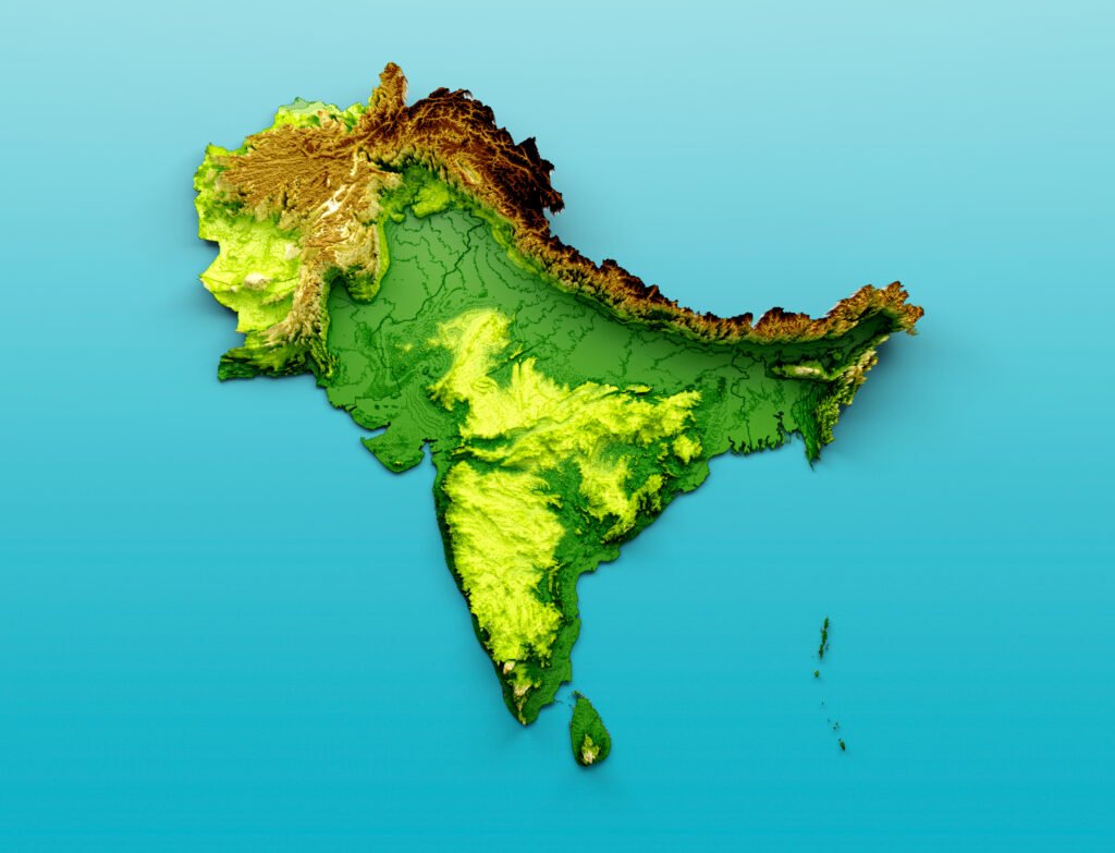
[ This is a map, physical map of india, with some of its neighbouring countries , this is often called indian subcontinent. Now we focus on india only ,the Yellow part is southern plateau, Green parts in North of india , is northern plain .Green parts in south ,both sides of plateau is ,narrower left side part of plateau is western coastal plain, and less narrow part in right side of plateau ,is eastern plain .Brown elevated part from the Top to stretched extreme right is ,northen mountain part , A little western part of rajasthan is desert. some islands are also in India.]
They are young fold mountains, still rising due to tectonic activity.
Three parallel ranges:
a. Himadri (Greater Himalayas):
The northernmost range, with permanently snow-covered peaks
Includes the world’s highest peaks, like Mount Everest (in Nepal) and Kanchenjunga (in India, 8,586 m)
b. Himachal (Lesser Himalayas):
Located south of Himadri
Famous hill stations like Shimla, Mussoorie, Nainital are found here
Moderate height and forested slopes
c. Shiwaliks (Outer Himalayas):
The southernmost and lowest range
Formed of unconsolidated sediments, prone to landslides and erosion
Home to narrow valleys and duns (e.g., Dehradun)
Eastern Hills or Purvanchal:
Extension of Himalayas in the northeast
Includes Patkai, Naga, Mizo Hills etc.
The Northern Plains:
Located south of the Himalayas, this vast fertile plain is formed by the deposition of alluvium by rivers like the Indus, Ganga, and Brahmaputra.
It spreads across Punjab, Haryana, Uttar Pradesh, Bihar, West Bengal, and parts of Assam.
Key features:
Formed by alluvial soil, making it extremely fertile and agriculturally productive
Densely populated due to flat terrain and water availability
Divided into:
Punjab Plains – drained by Indus and tributaries
Ganga Plains – largest area, between Ghaggar and Teesta
Brahmaputra Plains – mainly in Assam
Three regions based on elevation:
Bhabar: Narrow belt of coarse pebbles, immediately after Himalayas
Terai: Marshy, wet, and forested area south of Bhabar
Bhangar: Older alluvium, slightly elevated
Khadar: Newer alluvium, very fertile and prone to floods
The Peninsular Plateau:
Located south of the Northern Plains, it is triangular in shape.
It is the oldest landmass in India and formed due to the breaking and drifting of the Gondwana landmass.
Made of igneous and metamorphic rocks, rich in minerals and forests.
Divisions:
a. Central Highlands:
Lies north of the Narmada River
Includes Malwa Plateau, Bundelkhand, Baghelkhand
Bordered by the Aravalis in the northwest
Rivers: Chambal, Sind, Betwa, Ken flow from south to north
b. Deccan Plateau:
South of Narmada
Bounded by Western Ghats (steep) and Eastern Ghats (discontinuous)
Rivers like Godavari, Krishna, Kaveri, Mahanadi flow eastward
The Indian Desert:
Located in the northwestern part, mainly in Rajasthan, known as the Thar Desert
Receives less than 150 mm rainfall annually
Dominated by sand dunes, arid climate, and scarce vegetation
River Luni is the only prominent seasonal river
Soils are sandy, and water sources are few, called oases
The Coastal Plains:
India has two coastal plains stretching along the eastern and western coasts of the peninsula.
a. Western Coastal Plain:
Narrow and steep, lies between Western Ghats and Arabian Sea
Divided into:
Konkan Coast (Maharashtra-Goa)
Kannad Plain (Karnataka)
Malabar Coast (Kerala)
Features estuaries and backwaters (e.g., Kerala’s lagoons)
b. Eastern Coastal Plain:
Wide and flat, lies between Eastern Ghats and Bay of Bengal
Divided into:
Northern Circars (Andhra Pradesh)
Coromandel Coast (Tamil Nadu)
Rivers form deltas (e.g., of the Mahanadi, Godavari, Krishna, Kaveri)
The Islands:
India has two main island groups:
a. Andaman and Nicobar Islands:
Located in the Bay of Bengal
Comprise around 572 islands
Formed due to submarine volcanic activity
Rich in biodiversity and forests
b. Lakshadweep Islands:
Located in the Arabian Sea
Coral origin; consist of atolls and reefs
Smaller group with 36 islands
Capital: Kavaratti
Formation of Physical Features:
India’s physical features are a result of the movement of lithospheric plates:
Around 250 million years ago, the supercontinent Pangaea broke into Laurasia (north) and Gondwana (south).
The Indian plate, once part of Gondwana, moved northward, collided with the Eurasian plate, and caused the uplift of the Himalayas.
The Northern Plains were formed by the sediments from these mountains.
The Peninsular Plateau is stable and old, formed from ancient volcanic and tectonic activity.
Importance of Physical Features:
Mountains – source of rivers, protect from cold winds, home to glaciers and biodiversity
Plains – fertile soil, ideal for agriculture, dense population
Plateaus – rich in minerals and forests
Deserts – unique ecosystem, potential for solar energy
Coasts – fisheries, ports, trade, tourism
Islands – biodiversity hotspots, strategic defence locations
Conclusion:
India’s physical features play a crucial role in shaping its geography, climate, agriculture, natural resources, and human settlement. The variation from snow-capped Himalayas to hot deserts, fertile plains to rocky plateaus, and islands to long coastlines, makes India a country of incredible diversity. Understanding these features helps us appreciate the natural wealth of India and its regional uniqueness, as well as the challenges and opportunities they offer.
————————————————————————————————————————————————————————————————————————————
QUESTIONS FROM TEXTBOOK
Choose the right answer from the four alternatives given below:
(i) A landmass bounded by the sea on three sides is referred to as
(a) Coast
(b) Island
(c) Peninsula
(d) None of the above
Answer: (c) Peninsula
(ii) Mountain ranges in the eastern part of India forming its boundary with Myanmar are collectively called
(a) Himachal
(b) Uttarakhand
(c) Purvachal
(d) None of the above
Answer: (c) Purvachal
(iii) The western coastal strip, south of Goa is referred to as
(a) Coromandel
(b) Konkan
(c) Kannad
(d) Northern Circar
Answer: (c) Kannad
(iv) The highest peak in the Eastern Ghats is
(a) Anai Mudi
(b) Kanchenjunga
(c) Mahendragiri
(d) Khasi
Answer: (c) Mahendragiri
Answer the following questions briefly:
(i) What is the bhabar?
Answer: The bhabar is a narrow belt of about 8 to 16 km in width lying parallel to the slopes of the Shiwaliks. The rivers, after descending from the mountains, deposit pebbles in this region. This region is known as bhabar. All the streams disappear in this bhabar belt.
(ii) Name the three major divisions of the Himalayas from north to south.
Answer: The three major divisions of the Himalayas from north to south are:
The Great or Inner Himalayas or Himadri (northernmost range)
The Middle Himalayas or Himachal (Lesser Himalaya)
The Outer Himalayas or Shiwaliks
(iii) Which plateau lies between the Aravali and the Vindhya ranges?
Answer: The Malwa plateau lies between the Aravali and the Vindhya ranges.
(iv) Name the island group of India having coral origin.
Answer: The Lakshadweep Islands is the island group of India having a coral origin.
Distinguish between:
(i) Bhangar and Khadar
Answer:
Bhangar:
Lies above flood plains of the river
Older alluvium or old soil and forms the largest part of the northern plains
Composed of older alluvial deposits
Khadar:
It is a newer, younger deposit of flood plains
It is renewed every year
Composed of fresh alluvial deposits
(ii) Western Ghats and Eastern Ghats
Answer:
Western Ghats:
Lie parallel to the Western Coast
They are continuous and can be crossed through passes only
The Western Ghats’ average elevation is 900 – 1600 metres
They cause orographic rain by facing the rain-bearing moist winds to rise along the western slopes of the Ghats
The height of the Western Ghats progressively increases from north to south
Eastern Ghats:
Lie parallel to the Eastern Coast
They are discontinuous and irregular
The Eastern Ghats are dissected by rivers flowing into the Bay of Bengal
The Eastern Ghats’ average elevation is 600 metres
Which are the major physiographic divisions of India? Contrast the relief of the Himalayan region with that of the Peninsular plateau.
Answer:
The major physiographic divisions of India are:
The Himalayan Mountains
The Northern Plains
The Peninsular Plateau
The Indian Desert
The Coastal Plains
The Islands
Contrast between Himalayan region and Peninsular Plateau:
Geologically, the Peninsular Plateau constitutes one of the ancient landmasses on the earth’s surface. It was supposed to be one of the most stable land blocks. The Himalayas are the most recent landforms. From the viewpoint of geology, Himalayan mountains form an unstable zone. The whole mountain system of Himalaya represents a very youthful topography with high peaks, deep valleys and fast-flowing rivers. The northern plains are formed of alluvial deposits. The peninsular plateau is composed of igneous and metamorphic rocks with gently rising hills and wide valleys.
Give an account of the Northern Plains of India.
Answer:
The Northern Plains are the most recent landforms formed by the interplay of the three major river systems – the Indus, the Ganga and the Brahmaputra, along with their tributaries. This plain is formed of alluvial soil deposited over millions of years in a vast basin lying at the foothills of the Himalaya. It spreads over an area of 7 lakh sq. km, being about 2400 km long and 240 to 320 km broad, making it a densely populated physiographic division.
With rich soil cover combined with adequate water supply and favourable climate, it is agriculturally a productive part of India. The Northern Plain is broadly divided into three sections:
The Punjab Plains – The Western part formed by the Indus and its tributaries (Jhelum, Chenab, Ravi, Beas and Satluj). This section is dominated by the doabs.
The Ganga Plains – Extends between Ghaggar and Teesta rivers, spread over Haryana, Delhi, U.P., Bihar and partly Jharkhand.
The Brahmaputra Plains – Located further east in Assam.
The northern plains can be divided into four regions based on relief variations:
Bhabar – Narrow belt where rivers deposit pebbles
Terai – Wet, swampy region south of bhabar where streams re-emerge
Write short notes on the following:
(i) The Indian Desert
Answer:
The Indian desert lies towards the western margins of the Aravali Hills. It is an undulating sandy plain covered with sand dunes. This region receives very low rainfall with an average rainfall below 150 mm per year. It has an arid climate with low vegetation cover. Streams appear during the rainy season but soon disappear into the sand as they do not have enough water to reach the sea. Luni is the only large river in this region.
(ii) The Central Highlands
Answer:
The Central Highlands refer to the part of the Peninsular plateau lying to the north of the Narmada river, covering a major area of the Malwa plateau. The Central Highlands are wider in the west but narrower in the east. The eastward extensions of this plateau are locally known as the Bundelkhand and Baghelkhand. The Chotanagpur plateau marks the further eastward extension, drained by the Damodar river.
(iii) The Island groups of India
Answer:
Lakshadweep Islands:
The Lakshadweep group of islands is composed of small coral islands. Earlier they were known as Laccadive, Minicoy and Amindive. In 1973, these were renamed as Lakshadweep. It covers a small area of 32 sq km. The Kavaratti Island is the administrative headquarters of Lakshadweep. This island group has a great diversity of flora and fauna. The Pitti island, which is uninhabited, has a bird sanctuary.
Andaman and Nicobar Islands:
The elongated chain of islands located in the Bay of Bengal extending from north to south. They are bigger in size and are more numerous and scattered. The entire group is divided into two broad categories – The Andaman in the north and the Nicobar in the south. It is believed that these islands are an elevated portion of submarine mountains. These island groups are of great strategic importance for the country. There is a great diversity of flora and fauna in this group of islands too. These islands lie close to the equator and experience equatorial climate with thick forest cover.
————————————————————————————————————————————————————————————————————————————
OTHER IMPORTANT QUESTIONS FOR EXAMS
Part 1: Q1 to Q15
Section A: Multiple Choice Questions (Q1–Q10)
Q1. The Himalayas are what type of mountains?
(a) Block mountains
(b) Residual mountains
(c) Fold mountains
(d) Volcanic mountains
Answer: (c) Fold mountains
Q2. Which of the following rivers is not a Himalayan river?
(a) Ganga
(b) Yamuna
(c) Narmada
(d) Brahmaputra
Answer: (c) Narmada
Q3. What is the general orientation of the Himalayas?
(a) East-West
(b) North-South
(c) Southwest-Northeast
(d) Northwest-Southeast
Answer: (a) East-West
Q4. Which part of the Himalayas is composed of unconsolidated sediments?
(a) Himadri
(b) Himachal
(c) Shiwaliks
(d) Purvanchal
Answer: (c) Shiwaliks
Q5. The oldest landmass of India is:
(a) Northern Plains
(b) Himalayas
(c) Peninsular Plateau
(d) Coastal Plains
Answer: (c) Peninsular Plateau
Q6. The Northern Plains have been formed by the deposition of:
(a) Lava
(b) Sand
(c) Alluvium
(d) Coral
Answer: (c) Alluvium
Q7. Which of the following is not a part of the Peninsular Plateau?
(a) Malwa Plateau
(b) Deccan Plateau
(c) Chotanagpur Plateau
(d) Khadar Region
Answer: (d) Khadar Region
Q8. The Indian Desert is located in which state?
(a) Haryana
(b) Punjab
(c) Rajasthan
(d) Gujarat
Answer: (c) Rajasthan
Q9. Which river flows through a rift valley?
(a) Ganga
(b) Yamuna
(c) Brahmaputra
(d) Narmada
Answer: (d) Narmada
Q10. Which island group is of coral origin?
(a) Andaman Islands
(b) Nicobar Islands
(c) Lakshadweep Islands
(d) Maldives
Answer: (c) Lakshadweep Islands
Q11. What are the three main divisions of the Himalayas from north to south?
Answer: The three main divisions of the Himalayas from north to south are:
Himadri (Greater Himalayas)
Himachal (Lesser Himalayas)
Shiwaliks (Outer Himalayas)
Q12. What is a ‘dun’? Give an example.
Answer: A ‘dun’ is a narrow valley found between the Shiwalik and Himachal ranges. These are formed due to erosion and deposition. Example: Dehradun in Uttarakhand.
Q13. Which physical feature of India is rich in minerals and forests?
Answer: The Peninsular Plateau is rich in minerals and forests. It is composed of igneous and metamorphic rocks.
Q14. What are the Purvanchal hills?
Answer: The Purvanchal Hills are the eastern extension of the Himalayas, located in the northeastern states of India. They include hills like Patkai, Naga, Mizo, and Manipur Hills.
Q15. What is the difference between Khadar and Bhangar?
Answer:
Khadar is the newer alluvium, fertile and prone to flooding.
Bhangar is the older alluvium, found at a higher level and less fertile.
Part 2: Q16 to Q25
Section B: Short Answer Type Questions (continued)
Q16. Name the three major rivers that helped form the Northern Plains.
Answer: The Indus, Ganga, and Brahmaputra rivers are the three major river systems responsible for forming the Northern Plains through the deposition of alluvium.
Q17. What is the difference between the Eastern and Western Ghats?
Answer:
The Western Ghats are continuous, higher, and run parallel to the west coast.
The Eastern Ghats are discontinuous, lower, and run along the east coast.
Rivers cut across the Eastern Ghats but not the Western Ghats.
Q18. Which region is known as the storehouse of minerals in India? Why?
Answer: The Chotanagpur Plateau is known as the storehouse of minerals because it is rich in coal, iron ore, manganese, mica, and other mineral resources.
Q19. What is an alluvial plain? How is it formed?
Answer: An alluvial plain is a flat, fertile land formed by the deposition of alluvium brought down by rivers from higher regions like the Himalayas.
Q20. Mention two features of the Indian Desert.
Answer:
Receives very little rainfall (less than 150 mm annually)
Characterized by sandy soil, sand dunes, and extreme temperatures
Section C: Mid-Length Answer Type Questions (Q21–Q25)
(Answer in about 80–100 words each)
Q21. Describe the main features of the Peninsular Plateau.
Answer:
The Peninsular Plateau is the oldest landmass of India, formed from igneous and metamorphic rocks. It is triangular in shape, with the Vindhya and Satpura ranges in the north and bounded by the Western and Eastern Ghats. The plateau is divided into two parts:Central Highlands – lies to the north of the Narmada River and includes the Malwa Plateau.
Deccan Plateau – lies south of the Narmada, extends to Tamil Nadu, and is drained by east-flowing rivers like the Godavari, Krishna, and Kaveri.
It is rich in minerals, forests, and has a rugged terrain.
Q22. What are the characteristics of the Northern Plains of India?
Answer:
The Northern Plains are formed by the Indus, Ganga, and Brahmaputra river systems. They are made of alluvial soil, making them extremely fertile and suitable for agriculture. The region is densely populated due to flat land, fertile soil, and water availability. It is divided into:
Punjab Plains (west)
Ganga Plains (center)
Brahmaputra Plains (east)
The plain is further subdivided into Bhabar, Terai, Bhangar, and Khadar based on elevation and soil deposition.
Q23. How were the Himalayas formed?
Answer:
The Himalayas were formed due to the collision between the Indo-Australian Plate and the Eurasian Plate about 50 million years ago. The oceanic crust of the Tethys Sea between them was compressed and pushed upwards, forming fold mountains. The Himalayas are young and still growing due to continuous tectonic activity. They have three main ranges:
Himadri (Greater Himalayas)
Himachal (Lesser Himalayas)
Shiwaliks (Outer Himalayas)
This mountain system acts as a climatic barrier, source of rivers, and protector of the northern boundary.
Q24. Describe the features of coastal plains of India.
Answer:
India has two coastal plains:
Western Coastal Plains – Narrow, steep, extend from Gujarat to Kerala. Divided into Konkan, Kannad, and Malabar coasts. Features estuaries and backwaters.
Eastern Coastal Plains – Wide and flat, extend from West Bengal to Tamil Nadu. Divided into Northern Circars and Coromandel Coast. Major rivers like Mahanadi, Godavari, Krishna, and Kaveri form deltas here.
Both plains are important for fishing, agriculture, ports, and tourism.
Q25. What are the Purvanchal hills? Describe their features.
Answer:
The Purvanchal Hills are the eastern extension of the Himalayas, located in the northeastern states of India. They are composed of sedimentary rocks and are folded hills. These hills run along the India-Myanmar border. Major ranges include:
Patkai Hills
Naga Hills
Manipur Hills
Mizo Hills (Lushai Hills)
These hills are covered with dense forests and are important for tea plantations and bamboo.
Part 3: Q26 to Q30
Section D: Long Answer Type Questions (Detailed – Step-by-Step)
(Answer in 120–150 words each)
Q26. Explain the major physical divisions of India with examples.
Answer:
India can be divided into six major physical features:
The Himalayan Mountains:
Located in the north, formed by the collision of the Indian and Eurasian plates.
Divided into Himadri, Himachal, and Shiwaliks.
The Northern Plains:
Formed by the deposition of alluvium by Indus, Ganga, Brahmaputra rivers.
Fertile and densely populated.
The Peninsular Plateau:
Oldest part, made of hard rocks.
Includes Deccan Plateau, Central Highlands, Chotanagpur Plateau.
The Indian Desert:
In western Rajasthan.
Sandy soil, low rainfall, and dunes.
The Coastal Plains:
Along the east and west coasts.
Include Konkan, Malabar, Coromandel coasts.
The Islands:
Andaman & Nicobar in Bay of Bengal and Lakshadweep in Arabian Sea.
Q27. Describe the structure and importance of the Peninsular Plateau.
Answer:
Structure:
Triangular in shape, it lies south of the Northern Plains.
Formed from ancient igneous and metamorphic rocks.
Divided into:
Central Highlands (north of Narmada): Malwa Plateau, Bundelkhand, Baghelkhand.
Deccan Plateau (south of Narmada): Extends to Tamil Nadu.
Importance:
Rich in minerals like coal, iron, bauxite.
Covered with forests that support wildlife and rainfall.
Source of many rivers: Godavari, Krishna, Kaveri.
Suitable for farming and settlement on its edges.
Home to tribal communities and ancient civilizations.
Thus, the plateau is key to India’s natural resources and biodiversity.
Q28. How is the Northern Plain formed? Explain its divisions and importance.
Answer:
Formation:
Formed by deposition of alluvium from the Himalayan rivers over millions of years.
Rivers: Indus, Ganga, Brahmaputra and their tributaries brought sediment and created flat, fertile plains.
Divisions:
Punjab Plains: Formed by Indus and its tributaries.
Ganga Plains: Between Ghaggar and Teesta.
Brahmaputra Plains: Mainly in Assam.
Importance:
Extremely fertile soil (Khadar and Bhangar).
Densely populated and agriculturally productive.
Flat land supports transport and communication.
Plays a major role in India’s food grain production (e.g., rice, wheat).
The Northern Plain is often called the granary of India.
Q29. What is the significance of the Himalayas to India? Explain.
Answer:
The Himalayas are significant for India due to the following reasons:
Climatic Influence:
Act as a barrier to cold winds from Central Asia.
Cause the monsoon winds to shed rainfall on India.
Water Source:
Originate major rivers like Ganga, Yamuna, Brahmaputra.
Feed agriculture and drinking water needs.
Natural Barrier:
Provide protection against invasions historically.
Define India’s northern boundary.
Biodiversity:
Home to diverse flora and fauna.
Source of medicinal plants, forests, and wildlife.
Tourism and Pilgrimage:
Hill stations like Shimla, Darjeeling.
Pilgrimage sites like Amarnath, Kedarnath.
Thus, the Himalayas are vital for ecological balance, cultural identity, and national security.
Q30. How were the physical features of India formed? Explain the geological process briefly.
Answer:
India’s physical features were formed due to plate tectonics and geological activity over millions of years.
Gondwana Land:
India was part of the southern supercontinent Gondwana.
Tectonic Movements:
The Indo-Australian Plate drifted northwards and collided with the Eurasian Plate.
This collision led to the folding of rocks and formation of the Himalayas.
Deposition:
Rivers from the Himalayas deposited alluvium, forming the Northern Plains.
Volcanic Activity:
The Peninsular Plateau was shaped by ancient volcanic and igneous activity.
Erosion and Sedimentation:
Over time, wind, water, and glaciers shaped valleys, dunes, deltas, and plains.
This geological history created diverse landforms such as mountains, plateaus, plains, deserts, coasts, and islands, giving India its unique physical diversity.
————————————————————————————————————————————————————————————————————————————