Class 9 : Social Science (In English) – Lesson 11. India – Size and Location
EXPLANATION & SUMMARY
Introduction:
India is one of the most significant countries in Asia, both in terms of size and strategic location. The first chapter of NCERT’s Class 9 Geography book “Contemporary India” introduces students to India’s physical dimensions and its location in the world and Asia. The chapter explores how India’s geographical position affects its social, economic, and cultural relations with the rest of the world.
India’s Location and Extent:
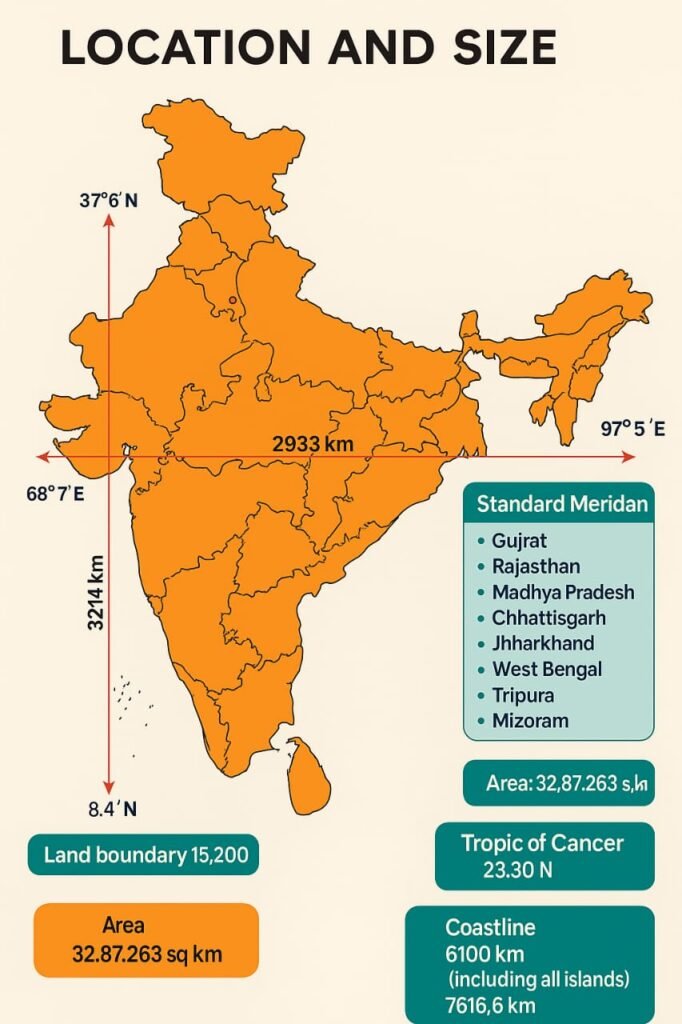
India is located entirely in the Northern Hemisphere. The latitudinal extent of India is from 8°4’N (near Kanyakumari) to 37°6’N (near Jammu & Kashmir), and the longitudinal extent is from 68°7’E (Gujarat) to 97°25’E (Arunachal Pradesh).
The Tropic of Cancer (23°30’N) passes almost halfway through the country, dividing it into two zones — tropical in the south and subtropical in the north.
The north-south extent (Kashmir to Kanyakumari) is about 3,214 km.
The east-west extent (Arunachal Pradesh to Gujarat) is about 2,933 km.
Time Difference:
Due to the vast east-west longitudinal extent of about 30°, there is a time difference of nearly two hours between the easternmost and westernmost parts of India. To maintain a uniform time across the country, Indian Standard Time (IST) is calculated from 82°30’E, which passes near Mirzapur in Uttar Pradesh.
Size of India:
India’s total land area is 3.28 million square kilometres. It is the seventh-largest country in the world.
It accounts for about 2.4% of the total land area of the world.
As per the 2024 estimate, India has a population of more than 1.4 billion, which makes it the second-most populous country after China.
The land boundary of India is about 15,200 km long.
The length of the total coastline including the mainland, Andaman & Nicobar Islands, and Lakshadweep is 7,516.6 km.
India and the World:
India’s central location at the head of the Indian Ocean is of great strategic importance:
It provides a southward extension of the Asian continent.
India’s location helps it establish close contact with West Asia, Africa, and Europe from the western coast, and with Southeast and East Asia from the eastern coast.
Historically, India’s location facilitated trade and cultural exchange with many ancient civilizations like Mesopotamia, Egypt, Rome, China, and Southeast Asia.
The Indian Ocean:
The ocean is named after India due to the country’s long coastline and prominent location in South Asia. India has a dominant presence in the Indian Ocean region, which contributes to its significance in maritime trade and diplomacy.
India’s Neighbours:
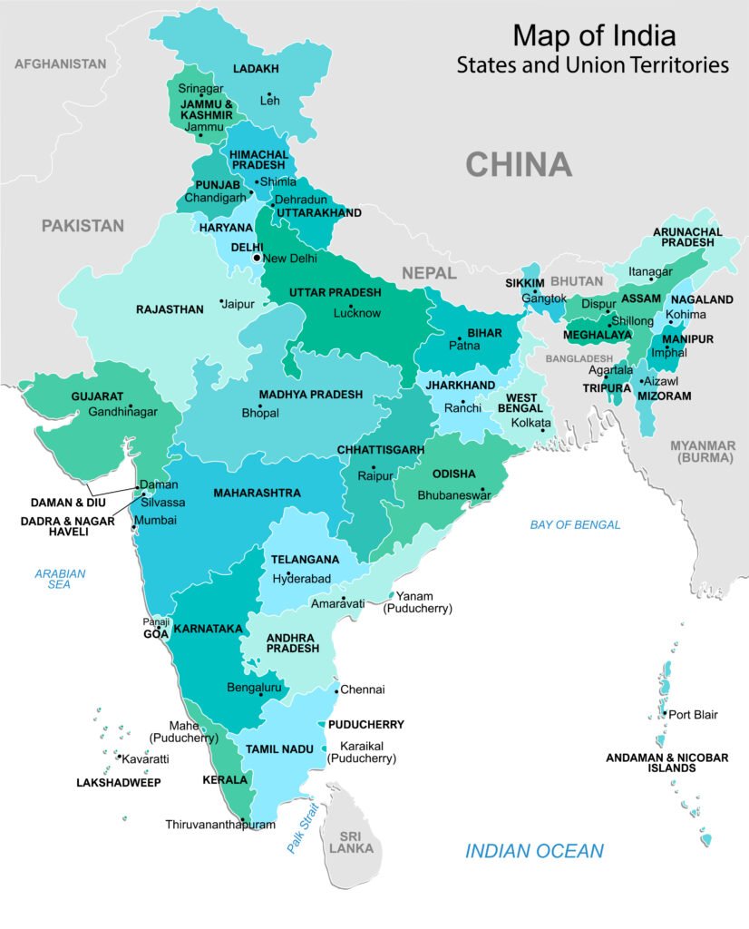
India shares its land boundaries with 7 countries:
Pakistan and Afghanistan in the northwest
China, Nepal, and Bhutan in the north
Bangladesh and Myanmar in the east
Important points about neighbours:
India has the longest boundary with Bangladesh (over 4,000 km).
The Palk Strait and Gulf of Mannar separate India from Sri Lanka.
The Himalayas form a natural barrier between India and its northern neighbours like China and Nepal.
Neighbouring Countries on Map:
Northwest – Pakistan, Afghanistan
North – China (Tibet), Nepal, Bhutan
East – Bangladesh, Myanmar
South (across the sea) – Sri Lanka and Maldives
India’s Political Divisions:
India is a federation of states consisting of 28 states and 8 Union Territories (as per the 2024 administrative structure).
These political divisions were formed largely on the basis of linguistic and cultural identities.
India’s Maritime Neighbours:
Besides land neighbours, India is also close to some island nations:
Sri Lanka is located to the southeast of India and is separated by the narrow sea channel called the Palk Strait.
The Maldives lie to the southwest of India in the Indian Ocean.
Importance of India’s Location:
a) Central Position in Asia:
India’s location gives it a central strategic position between East and West Asia. It acts as a bridge between Europe and Southeast Asia, facilitating both land and maritime trade.
b) Cultural Exchange:
India’s geographical location allowed cultural and religious interactions (like the spread of Buddhism, trade of spices and textiles) with other civilizations.
c) Trade Routes:
From ancient times, India was connected to the world through land routes (Silk Route) and sea routes, which contributed to the development of trade and the exchange of ideas.
d) Climate Moderation:
The surrounding oceans have a moderating influence on the coastal climate of India, especially the peninsular region.
Significance of the Indian Ocean:
India’s peninsular shape juts into the Indian Ocean, helping the country to:
Dominate trade routes to Africa, West Asia, and Southeast Asia.
Strengthen strategic relations with Indian Ocean countries.
Maintain naval presence and maritime security in the region.
The Indian Ocean has been a key area for India’s economic interests (oil shipping lanes, imports-exports) and foreign policy.
Conclusion:
India’s location and size are integral to understanding its geopolitical, cultural, and economic significance. Its vast landmass, diverse neighbours, and strategic location at the head of the Indian Ocean have shaped not only the country’s internal development but also its relations with the outside world. India’s location has made it a crossroad of trade, culture, and ideas for centuries, a legacy that continues to influence its role in global affairs today.
Important Keywords Recap:
Latitudinal Extent: 8°4’N to 37°6’N
Longitudinal Extent: 68°7’E to 97°25’E
Tropic of Cancer: 23°30’N
Standard Meridian: 82°30’E
Area: 3.28 million sq km
Coastline: 7,516.6 km
Neighbouring Countries: 7 land neighbours + 2 maritime neighbours
Indian Ocean: Strategic dominance
Importance: Trade, Culture, Climate, Politics
————————————————————————————————————————————————————————————————————————————
QUESTIONS FROM TEXTBOOK
(i) The Tropic of Cancer does not pass through
(a) Rajasthan
(b) Odisha
(c) Chhattisgarh
(d) Tripura
Answer: (b) Odisha
(ii) The easternmost longitude of India is
(a) 97° 25′ E
(b) 68° 7′ E
(c) 77° 6′ E
(d) 82° 32′ E
Answer: (a) 97° 25′ E
(iii) Uttarakhand, Uttar Pradesh, Bihar, West Bengal and Sikkim have common frontiers with
(a) China
(b) Bhutan
(c) Nepal
(d) Myanmar
Answer: (c) Nepal
(iv) If you intend to visit Kavarati during your summer vacations, which one of the following Union Territories of India will you be going to
(a) Puducherry
(b) Lakshadweep
(c) Andaman and Nicobar
(d) Daman and Diu
Answer: (b) Lakshadweep
(v) My friend hails from a country which does not share a land boundary with India. Identify the country.
(a) Bhutan
(b) Tajikistan
(c) Bangladesh
(d) Nepal
Answer: (b) Tajikistan
Answer the following questions briefly:
(i) Name the group of islands lying in the Arabian Sea.
Answer: The Lakshadweep Islands lie in the Arabian Sea to the southwest of the mainland.
(ii) Name the countries which are larger than India.
Answer: The countries which are larger than India are Russia, Canada, the U.S.A, China, Brazil and Australia. Russia is the largest of all countries, with an area of 17.09 million sq.km, while India has an area of 3.28 million sq.km.
(iii) Which island group of India lies to its south-east?
Answer: The Andaman and Nicobar Islands lie to the south-east of India in the Bay of Bengal.
(iv) Which island countries are our southern neighbours?
Answer: The island countries that are our southern neighbours are Sri Lanka and the Maldives. Maldives Islands are situated to the south of the Lakshadweep Islands, whereas Sri Lanka is separated from India by a narrow channel of sea formed by the Palk Strait and the Gulf of Mannar.
(V) The sun rises two hours earlier in Arunachal Pradesh as compared to Gujarat in the west, but the watches show the same time. How does this happen?
Answer: The latitudinal and longitudinal extent of India is about 30°. The east-west extent is smaller than the north-south extent. There is a time lag of two hours from Gujarat to Arunachal Pradesh. As Arunachal Pradesh lies on the eastern side of India, the sun rises here earlier when compared to Gujarat. The time along the Standard Meridian of India (82°30’E) passing through Mirzapur (in Uttar Pradesh) is taken as the standard time for the whole country. The latitudinal extent influences the duration of day and night as one moves from south to north. Therefore, the watches show the same time in all parts of the country.
(Vi) The central location of India at the head of the Indian Ocean is considered of great significance. Why?
Answer: India is a southward extension of the Asian continent and is located in a central position between East and West Asia. The Indian Ocean provides a strategic central location to India, as it connects the East Asian countries with Europe in the West. The Deccan Peninsula also protrudes into the Indian Ocean, thus helping India establish close contact with West Asia, Africa and Europe from the western coast and with Southeast and East Asia from the eastern coast. There is no other country like India in the world which has a long coastline on the Indian Ocean and thus, justifying the naming of an ocean after it.
Map Skills Questions
Identify the following with the help of map reading:
(i) The island groups of India lying in the Arabian Sea and the Bay of Bengal.
Answer: The Lakshadweep Islands lie in the Arabian Sea, and the Andaman and Nicobar Islands lie in the Bay of Bengal
(ii) The countries constituting Indian subcontinent.
Answer: India, Pakistan, Bangladesh, Nepal, Bhutan, Afghanistan, and Sri Lanka constitute the Indian subcontinent.
(iii) The States through which the Tropic of Cancer passes.
Answer: The Tropic of Cancer passes through Gujarat, Rajasthan, Madhya Pradesh, Chhattisgarh, Jharkhand, West Bengal, Tripura, and Mizoram.
(iv) The northernmost latitude in degrees.
Answer: The northernmost latitude of India is 37°6’N.
(v) The southernmost latitude of the Indian mainland in degrees.
Answer: The southernmost latitude of the Indian mainland is 8°4’N.
(vi) The eastern and the western-most longitude in degrees.
Answer: The easternmost longitude is 97°25’E and the westernmost longitude is 68°7’E.
(vii) The place situated on the three seas.
Answer: Kanyakumari is situated on the three seas – the Arabian Sea, the Bay of Bengal, and the Indian Ocean.
(viii) The strait separating Sri Lanka from India.
Answer: The Palk Strait separates Sri Lanka from India.
(ix) The Union Territories of India.
Answer: The Union Territories of India are Andaman and Nicobar Islands, Chandigarh, Dadra and Nagar Haveli and Daman and Diu, Lakshadweep, Delhi, Puducherry, Jammu and Kashmir, and Ladakh.
————————————————————————————————————————————————————————————————————————————
OTHER IMPORTANT QUESTIONS FOR EXAMS
CBSE MODEL QUESTION PAPER
Part 1: Q1 to Q15
Section A: Multiple Choice Questions (Q1–Q10)
Q1. What is the latitudinal extent of India?
(a) 8°4’N to 37°6’N
(b) 7°4’N to 38°6’N
(c) 6°4’N to 39°6’N
(d) 9°4’N to 36°6’N
Answer: (a) 8°4’N to 37°6’N
Q2. Which line passes almost midway through India from east to west?
(a) Equator
(b) Prime Meridian
(c) Tropic of Capricorn
(d) Tropic of Cancer
Answer: (d) Tropic of Cancer
Q3. The longitudinal extent of India is:
(a) 68°7’W to 97°25’E
(b) 68°7’E to 97°25’E
(c) 66°7’E to 99°25’E
(d) 65°7’E to 96°25’E
Answer: (b) 68°7’E to 97°25’E
Q4. The Indian Standard Time is calculated from which meridian?
(a) 82°30’W
(b) 80°30’E
(c) 82°30’E
(d) 84°30’E
Answer: (c) 82°30’E
Q5. What is the total area of India?
(a) 3.28 million sq km
(b) 2.28 million sq km
(c) 4.28 million sq km
(d) 5.28 million sq km
Answer: (a) 3.28 million sq km
Q6. India’s size is about what percent of the total geographical area of the world?
(a) 4.4%
(b) 2.4%
(c) 3.4%
(d) 5.4%
Answer: (b) 2.4%
Q7. Which neighbouring country lies to the northwest of India?
(a) Nepal
(b) Myanmar
(c) Pakistan
(d) Bangladesh
Answer: (c) Pakistan
Q8. Which island country lies to the south-east of India?
(a) Maldives
(b) Andaman
(c) Sri Lanka
(d) Lakshadweep
Answer: (c) Sri Lanka
Q9. The north-south extent of India is approximately:
(a) 2,933 km
(b) 3,214 km
(c) 1,214 km
(d) 4,214 km
Answer: (b) 3,214 km
Q10. The east-west extent of India is approximately:
(a) 2,933 km
(b) 3,314 km
(c) 3,214 km
(d) 2,734 km
Answer: (a) 2,933 km
Section B: Short Answer Type Questions (Q11–Q15)
Q11. What is the significance of the Tropic of Cancer in India?
Answer: The Tropic of Cancer (23°30’N) divides India into two almost equal halves — the tropical zone in the south and the subtropical zone in the north. It influences the climatic variations in the country.
Q12. Name the neighbouring countries of India that lie to its north.
Answer: The neighbouring countries of India to the north are China, Nepal, and Bhutan.
Q13. What is the importance of the Indian Ocean for India?
Answer: The Indian Ocean provides India with a strategic location, enables maritime trade with Africa and Southeast Asia, and enhances India’s influence in the region.
Q14. Why does India have a time lag of two hours between its eastern and western parts?
Answer: Because of India’s vast longitudinal extent (about 30°), there is a time lag of two hours between Arunachal Pradesh in the east and Gujarat in the west
Q15. Which countries share land boundaries with India in the east?
Answer: The countries sharing land boundaries with India in the east are Bangladesh and Myanmar.
Part 2: Q16 to Q25
Section B: Short Answer Type Questions (continued)
Q16. Why does India use 82°30’E as its Standard Meridian?
Answer: India uses 82°30’E as the Standard Meridian because it passes approximately through the center of the country (near Mirzapur in Uttar Pradesh) and helps maintain a uniform standard time across all regions.
Q17. Name the island groups of India and their locations.
Answer: India has two main island groups:
Andaman and Nicobar Islands – located in the Bay of Bengal (southeast of mainland India)
Lakshadweep Islands – located in the Arabian Sea (southwest of mainland India)
Q18. How has India’s location helped in establishing cultural and economic contacts with the outside world?
Answer: India’s central location at the crossroads of Asia, with access to the Indian Ocean, allowed it to engage in maritime and land trade with Africa, West Asia, and Southeast Asia. It also enabled the spread of cultural ideas, religions, and technologies.
Q19. What is the total length of India’s land boundary and coastline?
Answer: India’s total land boundary is about 15,200 km and the coastline including islands is about 7,516.6 km.
Q20. Name two neighbouring countries of India that are landlocked.
Answer: Two landlocked neighbouring countries of India are Nepal and Bhutan.
Section C: Mid-Length Answer Type Questions (Q21–Q25)
(Answer in about 80–100 words each)
Q21. Describe the geographical extent of India in terms of latitude and longitude.
Answer: India extends from 8°4’N to 37°6’N latitude and 68°7’E to 97°25’E longitude. The north-south extent is about 3,214 km, and the east-west extent is about 2,933 km. The Tropic of Cancer (23°30’N) passes almost halfway through the country. Due to this wide longitudinal stretch, there is a time difference of about two hours between the eastern and western ends. To avoid confusion, Indian Standard Time (IST) is calculated from 82°30’E.
Q22. Why is India called a subcontinent?
Answer: India is called a subcontinent because of its vast size, distinct geographical features, and cultural diversity. It has natural boundaries like the Himalayas in the north and oceans on three sides. It also includes a wide variety of landforms, climates, and resources, and was historically referred to as the Indian Subcontinent because of its individuality within the Asian continent.
Q23. Mention the importance of India’s strategic location.
Answer: India’s central location at the head of the Indian Ocean gives it a strategic advantage in connecting with Europe and Africa via the western sea routes and East and Southeast Asia via the eastern sea routes. This location made India a center of trade, culture, and political influence for centuries and continues to play a role in regional and global affairs.
Q24. Explain the impact of India’s location on its climate.
Answer: India’s location near the equator and Tropic of Cancer leads to diverse climatic conditions. The southern part has a tropical climate, while the northern part has subtropical climate. The oceans surrounding the country help in moderating the coastal climate and contribute to the monsoon winds, which are crucial for Indian agriculture.
Q25. How do India’s physical features and location help in its international relations?
Answer: India’s location and physical features such as mountains and oceans have helped it maintain defensive boundaries, trade links, and cultural exchange. Its accessibility by both land and sea allowed India to build strong historical ties with countries in Asia, Africa, and Europe. Today, this location supports diplomatic relations, international trade, and maritime security in the Indian Ocean region.
Q26. Discuss the implications of India’s location on its cultural and economic development.
Answer:
India’s location has had a significant impact on its cultural and economic development:
Cultural Interaction: Being centrally located between East and West Asia, India acted as a bridge for cultural exchanges. Ideas such as Buddhism, mathematics, and architecture spread from India to Southeast and Central Asia.
Historical Trade Routes: Ancient land routes connected India with Mesopotamia, Central Asia, China, and Europe. Coastal trade flourished via the Arabian Sea and Bay of Bengal, encouraging the exchange of spices, silk, and textiles.
Maritime Importance: India’s long coastline and proximity to major sea lanes gave it strategic control over the Indian Ocean, which was used by traders from Africa, Arabia, and Southeast Asia.
Modern Relevance: Today, India’s central location helps in maintaining strong economic ties with Gulf countries, ASEAN nations, and Africa, and supports its role in international diplomacy.
Q27. Why is the Indian Ocean named after India? Explain with reasons.
Answer:
The Indian Ocean is the only ocean named after a country, and that country is India, due to the following reasons:
Strategic Centrality: India has a long coastline along the Indian Ocean, and its triangular peninsular shape juts into the ocean, giving it a commanding position.
Historical Significance: Since ancient times, Indian merchants and sailors used this ocean for trade and navigation. The subcontinent’s influence extended over much of the oceanic region.
Geographical Dominance: India is the largest and most prominent country bordering this ocean. Its geographical position in the north-central part of the ocean makes it a dominant player.
Cultural and Trade Connections: The Indian Ocean facilitated cultural exchanges and commerce with regions like Arabia, East Africa, and Southeast Asia, making India a historical hub of economic activity.
Q28. How does India’s location help in maintaining relations with other countries? Discuss with examples.
Answer:
India’s geographical location plays a vital role in its international relations:
With West Asia and Africa: India’s western coast faces West Asia and East Africa, enabling strong economic relations, especially in oil trade and Indian diaspora connections.
With Southeast and East Asia: The eastern coast opens to Southeast Asia, facilitating trade with Singapore, Thailand, Indonesia, and China. India is a part of ASEAN+ forums.
With Oceanic Neighbours: Maritime proximity to Sri Lanka and Maldives promotes regional cooperation. India’s SAGAR initiative (Security and Growth for All in the Region) focuses on strengthening ties in the Indian Ocean Region.
Shipping Routes: India is located near major sea lanes like the Suez Canal–Malacca route, enhancing its importance in global shipping and defence strategy.
Hence, India’s location enables it to play a leadership role in South Asia and beyond.
Q29. Describe India’s relations with its neighbouring countries based on geography.
Answer:
India shares land boundaries with seven countries and has two maritime neighbours:
Pakistan and Afghanistan (Northwest): India shares a tense relationship with Pakistan due to historical conflicts, especially over Jammu & Kashmir. With Afghanistan, India maintains development partnerships.
China, Nepal, Bhutan (North):
With China, relations are mixed—strong economic ties but also border tensions.
With Nepal and Bhutan, India shares friendly and culturally linked relations, supported by open borders and trade.
Bangladesh and Myanmar (East):
India has improved its relations with Bangladesh through economic and water-sharing agreements.
With Myanmar, India promotes regional connectivity (e.g., Kaladan project) and counters insurgency threats.
Sri Lanka and Maldives (Across the sea):
Shared maritime borders, cultural ties, and strategic cooperation mark India’s friendly relations with both nations.
Thus, India’s geography shapes both its security concerns and cooperative engagements.
Q30. Explain the longitudinal and latitudinal extent of India and its impact on time and climate.
Answer:
India extends from 8°4’N to 37°6’N latitude and 68°7’E to 97°25’E longitude. This vast extent has two major effects:
Impact on Time:
India covers about 30 degrees of longitude.
Each 15° of longitude equals 1 hour of time difference.
Hence, the easternmost and westernmost parts of India have a time gap of about 2 hours.
To avoid confusion, Indian Standard Time (IST) is fixed at 82°30’E, passing through Mirzapur, and is used throughout the country.
Impact on Climate:
The southern part, near the equator, has a tropical climate with higher temperatures and more humidity.
The northern part, closer to the Himalayas, has a subtropical climate with distinct seasons and lower temperatures.
The Tropic of Cancer divides the country climatically, influencing monsoon arrival and vegetation patterns.
This geographical span results in diverse weather, agriculture, and lifestyle across regions.
———————————————————————————————————————————————————————————————————————————–
MAPS