
Class 12 : History (English) – Lesson 7 An Imperial Capital: Vijayanagara
EXPLANATION & SUMMARY
Hampi ,Ruins of Vijayanagar Empire
🔵 Explanation
🟢 Setting the scene: why Vijayanagara matters
🔵 Vijayanagara was one of the most powerful kingdoms of medieval South India, ruling from the mid-fourteenth to the sixteenth centuries.
🟡 Its capital at Hampi rose on a rocky granite landscape along the Tungabhadra River, where hills, boulders, and water channels naturally protected the site.
🔴 The city became a hub of administration, religion, trade, craft production, and military power, leaving behind a vast archaeological landscape that historians continue to study.
💡 Concept: A capital is not only a political headquarters; it is also a planned environment that expresses a ruler’s vision through temples, palaces, fortifications, water systems, and markets.
🟢 Founding and dynasties
🔵 Vijayanagara’s foundation is associated with the Sangama brothers, Harihara and Bukka (1336 CE), who consolidated territories in the Deccan and deep south.
🟡 After the Sangamas came the Saluva, Tuluva, and Aravidu dynasties; among these, the Tuluva king Krishnadevaraya (r. 1509–1529) is remembered for extensive conquests, patronage of temples and irrigation, and encouragement to literature.
🔴 The kingdom interacted with neighbouring powers: Bahmani and successor Deccan Sultanates to the north, the Gajapati rulers of Odisha to the northeast, and coastal polities engaged in overseas trade.
✏️ Note: Even when dynasties changed, many institutions—like the amara-nayaka system—continued with adjustments, giving the state both continuity and flexibility.
🟢 Royal power and the amara-nayaka system
🔵 Amara-nayakas were military chiefs who received assignments of revenue-yielding villages or lands (amaram) in lieu of salaries.
🟡 In return, they maintained troops, horses, and elephants, presented annual tribute, and rendered military service when summoned.
🔴 Nayakas exercised considerable local authority—collecting revenue, settling disputes, and patronising temples—but remained bound to the king through rituals of loyalty and periodic transfers.
✔️ This arrangement created a networked polity: the centre depended on local elites for military strength; local elites drew their legitimacy from royal protection and ritual recognition.
🟢 Geography and city plan: using stone, water, and slopes
🔵 The capital was conceived within a dramatic terrain of granite ridges and valleys. City builders aligned fort walls along ridgelines, funnelling movement through controlled gateways.
🟡 Urban space spread over distinct zones: a Royal Centre with palatial platforms and audience halls; a Sacred Centre with major temples; and an expansive suburban belt of fields, tanks, workshops, and satellite settlements.
🔴 Massive boulders, dressed stone, and mud-core ramparts formed fortifications with bastions and watchtowers.
💡 Concept: Instead of a single encircling wall, multiple lines of fortification created nested security—an outer agrarian-market belt protected the inner administrative and sacred cores.
🟢 Water management and agrarian base
🔵 Deccan plateaus depend on careful water control; Vijayanagara rulers sponsored canals from the Tungabhadra, large tanks, sluices, and stepped wells.
🟡 These works supported paddy, pulses, and garden crops and enabled the city to feed a large population, while orchards and groves around temples and palaces beautified the landscape.
🔴 Rights and maintenance were often tied to temple endowments and local communities, showing how ritual institutions and irrigation economies reinforced each other.
✔️ Productive agriculture underwrote military campaigns, festivals, and monumental building.
🟢 Temples, rituals, and kingship
🔵 Temples served as sacred landmarks, economic institutions, and political stages.
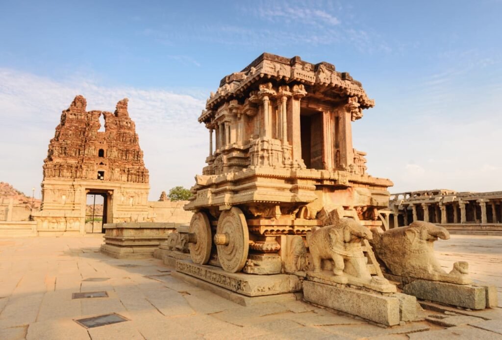
🟡 The Virupaksha complex at Hampi is an ancient Shaiva centre that continued to attract pilgrims; the Vitthala complex is known for its ornate mandapas and the famous stone chariot (a shrine) within a sprawling sacred campus.
🔴 Tall gopurams (gateway towers), pillared halls, and processional routes linked sacred and urban spaces.
💡 Concept: Royal authority was performed publicly—processions, gift-giving, and festival spectacles visualised the king’s role as protector of dharma and benefactor of gods and subjects.
🟢 Royal Centre: architecture of authority
🔵 The Royal Centre housed platforms, audience pavilions, ceremonial enclosures, and residential zones for the court.
🟡 The Mahanavami Dibba—a high ceremonial platform—was used during Dasara (Mahanavami) festivities; from here the ruler viewed processions, military parades, hunting displays, and tribute-bearing chiefs.
🔴 Reliefs on ceremonial structures show envoys, elephants, horses, dancers, and musicians, hinting at the diversity of people and performances gathered at court.
✏️ Note: Palaces were often built in perishable materials over stone bases, which is why we mainly see basements, platforms, and waterworks today.
🟢 Markets, craft production, and trade
🔵 Broad streets flanked by bazaars led to major temples; travellers describe stalls selling textiles, precious stones, perfumes, metalware, and horses.
🟡 Merchants handled inland and overseas trade via west-coast ports; the kingdom imported quality horses and exported textiles and spices through commercial intermediaries.
🔴 Workshops near quarries and rivers produced sculpture, pillars, and architectural members; other clusters specialised in metalwork, bead-making, and everyday craft.
✔️ Market avenues near temples show how ritual traffic and commerce were intertwined—pilgrimage generated steady demand for food, flowers, textiles, and services.
🟢 Sources for Vijayanagara’s history
🔵 Epigraphs (inscriptions) record grants, taxes, temple donations, and victories, helping reconstruct administration and social life.
🟡 Literary works in Sanskrit and regional languages praise kings, describe rituals, and preserve courtly ideals.
🔴 Foreign accounts—such as those of Persian envoys and Portuguese visitors—comment on ceremonies, markets, and military practices; they need cross-checking but add vivid detail.
💡 Concept: Historians compare inscriptions, architecture, archaeology, and travelogues to build a more reliable picture—each source type has strengths and biases.
🟢 Social worlds of the capital
🔵 The city drew a mixed population: Brahmana scholars, artisans, merchants, soldiers, temple servants, and entertainers.
🟡 Temples and courts employed large numbers—cooks, flower-sellers, drummers, dancers, guards—creating an urban service economy anchored in ritual calendars.
🔴 Women appear in varied roles: as patrons, performers, craft workers, and household managers; some temple women were linked to ritual singing and dance.
✔️ Urban neighbourhoods had internal hierarchies but were knit together by markets, festivals, and shared water resources.
🟢 Everyday governance and taxation
🔵 Revenue came from land tax, customs on markets and ports, fines, and tributes from subordinate chiefs.
🟡 Village assemblies and local officials assessed crops and maintained bunds and canals; part of the revenue supported temples, repairs, and public works.
🔴 Nayakas supervised policing and order in their jurisdictions while the court regulated elite competition through transfers and ceremonial honours.
✏️ Note: Because amara-nayakas kept troops at their own cost, the state could field large armies quickly but had to continually manage elite loyalties.
🟢 Warfare, diplomacy, and frontiers
🔵 Armies included infantry, cavalry, war-elephants, and artillery; quality cavalry depended on imported horses, making control of port access crucial.
🟡 Diplomacy alternated with conflict against the Deccan sultanates and Odisha Gajapatis; fort belts and outposts guarded key passes and river fords.
🔴 Victories brought tribute and new lands; defeats risked the defection of frontier chiefs—hence the constant need to display royal prowess through festivals and gifts.
✔️ The political map was fluid: alliances shifted, and military balance could change quickly with elite defections or loss of supply lines.
🟢 Festivals and public spectacle
🔵 Mahanavami (Dasara) was the kingdom’s grand public ritual—days of processions, dance, music, wrestling, and animal displays culminated in royal appearances atop the viewing platform.
🟡 Tribute-bearers, embassies, and nayakas presented gifts; the city’s avenues and mandapas turned into theatres of sovereignty.
🔴 Such spectacles reaffirmed hierarchies but also integrated diverse groups into a common civic experience centred on the king and the gods.
💡 Concept: Ritual performance was political communication—loyalty was staged, witnessed, and remembered.
🟢 Art and style
🔵 Vijayanagara architecture developed a distinctive idiom: robust granite bases, profuse pilasters, carved columns, and tall gopurams emphasised verticality and grandeur.
🟡 The Vitthala temple’s mandapas feature ornate colonnettes and the well-known “musical” pillar clusters; the stone chariot shrine within the courtyard has become an emblem of Hampi.
🔴 Relief panels across royal and sacred spaces depict epics, court scenes, processions, and animal motifs, blending sacred narrative with royal propaganda.
✔️ The style spread beyond the capital through patronage of regional nayakas, creating a wider cultural zone in the south.
🟢 After 1565 and legacy
🔵 In 1565, a confederation of Deccan sultanates defeated the Vijayanagara army near Talikota; Hampi was sacked and many buildings damaged.
🟡 The political centre later shifted to places like Penukonda and Chandragiri under the Aravidu line, but the capital’s urban fabric never regained its earlier density.
🔴 Nayaka polities in the Tamil region (such as at Madurai and Thanjavur) carried forward many features: temple-centred urbanism, processional cultures, and patronage of artisans.
✔️ Today, the Hampi-Vijayanagara landscape stands as a major archaeological and heritage zone, allowing historians to explore everyday life, economy, and statecraft through ruins, inscriptions, and terrain.
🟢 How historians read the city on the ground
🔵 Fort walls track ridge lines, revealing a defensive logic that uses the land itself as armour.
🟡 Gateways with bent-axis entries slow and survey movement; guard-rooms and bastions cluster around chokepoints.
🔴 Water channels cut across slopes, feeding tanks near fields; sluice remains and stepped wells show layered interventions over time.
💡 Concept: Urban archaeology treats the whole landscape—hills, fields, water, walls, shrines, markets—as one interlocked system rather than isolated monuments.
🟢 Economy in motion: from field to festival
🔵 Agricultural surplus moved along cart tracks and canals into city markets, where guilds and shop clusters specialised in grain, oil, cloth, and metal.
🟡 Temple kitchens required steady supplies of rice, ghee, spices, and flowers; festivals stimulated short-term demand for textiles, garlands, and lamps.
🔴 Taxes at gates and market squares funded guards, cleaning, and street repairs—city order was an everyday, paid-for service.
✔️ Imports like horses and some luxury goods came through west-coast ports, highlighting the capital’s dependence on long-distance trade networks.
🟢 Belief, inclusion, and boundaries
🔵 Pilgrims from varied linguistic regions came to Hampi’s shrines; merchants and soldiers from distant places settled near their work sites.
🟡 While social hierarchies persisted, ritual spaces—processional streets, temple courtyards, khanavalis (feeding places)—drew people into shared activity.
🔴 The state used endowments, honours, and festivals to fold local groups into a wider imperial community.
✏️ Note: Inclusion was strategic and performative; it could be generous yet always under the sign of royal authority.
🟢 Reading traveller accounts with care
🔵 Visitors often compared Vijayanagara with cities they knew, praising its size, markets, and splendour.
🟡 Some noted the strict policing of streets and the magnificence of ceremonies; others described gem markets and horse fairs.
🔴 Such texts may exaggerate or misunderstand local customs, so historians corroborate them with inscriptions and material remains before drawing conclusions.
✔️ Cross-checking prevents us from mistaking rhetorical flourish for fact.
🟢 Why Vijayanagara’s capital still teaches us
🔵 It shows how rulers could mould a challenging landscape into a thriving city by layering fortification, water engineering, ritual routes, and market streets.
🟡 It demonstrates how power relies on cooperation with local elites and communities, visualised in public ceremonies and cemented through endowments.
🔴 It reveals the delicate balance between central authority and military subcontractors: a system that yielded expansion but could fragment when elite ties broke.
💡 Concept: Capitals are living systems—part fortress, part farm, part shrine, part marketplace—held together by ideas of kingship and the practicalities of everyday supply.
🟡 Summary (~300 words)
🔵 Vijayanagara emerged in the fourteenth century and developed into a dominant South Indian power. Its capital at Hampi occupied a naturally defensible granite landscape along the Tungabhadra River. The city’s plan integrated fort walls aligned to ridges, controlled gateways, and multiple urban rings: an agrarian-market belt, a Royal Centre for courtly functions, and a Sacred Centre with major temples.
🟢 The kingdom’s political structure relied on amara-nayakas—military chiefs who received revenue assignments in return for troops, tribute, and loyalty. This networked system allowed rapid mobilisation but required constant management of elite relations. Revenue came from land tax and market levies; irrigation canals, tanks, and wells sustained intensive agriculture, orchards, and gardens.
🟡 Temples such as Virupaksha and Vitthala served as spiritual landmarks and economic hubs. Gopurams, pillared mandapas, processional routes, and ceremonial platforms like the Mahanavami Dibba made the city a theatre of sovereignty where festivals displayed hierarchy, loyalty, and abundance. Markets along processional streets sold textiles, gems, metalwork, perfumes, and horses; workshops supplied sculptural and architectural elements.
🔴 Sources include inscriptions recording grants and taxes, literary compositions celebrating kings, and foreign travelogues describing ceremonies, markets, and military arrangements. Archaeology ties these records to the physical landscape—forts, tanks, streets, quarries—showing a functional whole rather than isolated monuments.
🟢 After the defeat near Talikota in 1565, Hampi was sacked; later rulers continued elsewhere, and regional nayakas carried forward many cultural forms. The capital’s remains today help historians study statecraft, economy, ritual, and urban planning in a pre-modern setting.
✔️ In essence, Vijayanagara’s imperial capital was an engineered landscape where water control, military design, ritual performance, and commerce were fused to project royal authority and sustain a diverse urban society.
📝 Quick Recap
🟢 Location and layout: granite ridges, Tungabhadra canal systems, nested fortifications, Royal and Sacred Centres.
🔵 Power and polity: amara-nayaka network linked local military elites to the king through revenue rights and ritual loyalty.
🟡 Temples and ritual: Virupaksha, Vitthala, processional streets, Mahanavami Dibba—politics staged as public spectacle.
🔴 Economy: irrigation-fed agriculture, bazaars, craft clusters, horse imports; taxes funded urban services.
🟣 Sources: inscriptions, literature, travellers’ accounts, and archaeology used together to reconstruct the city.
🟠 Legacy: post-1565 dispersal but enduring cultural imprint; the Hampi landscape remains a key archive for India’s medieval urbanism.
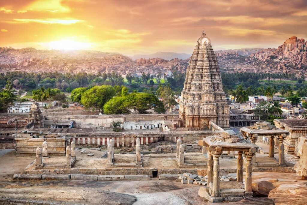
Virupaksha temple, Vijayanagar Empire
————————————————————————————————————————————————————————————————————————————
QUESTIONS FROM TEXTBOOK
🔵 Question 1: What have been the methods used to study the ruins of Hampi over the last two centuries? In what way do you think they would have complemented the information provided by the priests of the Virupaksha temple?
🟢 Answer 1 (≈145 words):
🟡 Epigraphers recorded and read stone and copper-plate inscriptions to reconstruct kings, grants, taxes and temple endowments.
🔵 Archaeologists mapped walls, water-works, streets and building-bases; excavations dated layers and recovered ceramics, beads, coins and tools.
🟢 Architectural historians analysed plans (temples, mandapas, platforms, gateways) to infer functions and building sequences.
🟡 Historical geographers used terrain survey to relate ridges, canals and fields to fortification lines.
🔵 Since the twentieth century, photography, measured drawings and later remote-sensing improved accuracy; travellers’ accounts were critically compared with the material record.
🟢 Priests of Virupaksha temple preserve ritual calendars, local genealogies, festival routes and sacred lore remembered in the community.
🟡 The two bodies of knowledge are complementary: ritual memory explains meanings and usage of spaces; archaeology and epigraphy verify dates, patrons and spatial extent.
🔵 Together they yield a fuller picture—what was believed and performed, and what was built, endowed and inhabited.
🔵 Question 2: How were the water requirements of Vijayanagara met?
🟢 Answer 2 (≈130 words):
🟡 Engineers diverted Tungabhadra water through canals to tanks and reservoirs around the city; bunds and sluices regulated supply to fields and gardens.
🔵 Large tanks near Kamalapura and other valleys stored monsoon runoff; feeder channels linked stepped wells and distribution cisterns.
🟢 Temple and palace complexes had wells, sumps and stone-lined channels for kitchens, rituals and bathing.
🟡 Terraced fields on valley floors received controlled irrigation; overflow drains protected embankments and returned water to lower tanks.
🔵 Maintenance was tied to royal/nayaka endowments and local communities responsible for desilting and repairs.
🟢 This integrated system—canals, tanks, wells and drains—met urban, ritual and agricultural needs, stabilised harvests and supported a large population in a semi-arid landscape.
🔵 Question 3: What do you think were the advantages and disadvantages of enclosing agricultural land within the fortified area of the city?
🟢 Answer 3 (≈140 words):
🟡 Advantages:
➡️ Secure food supply during siege; fields, orchards and fodder lay under the army’s protection.
➡️ Revenue and granaries remained within guarded gates, reducing losses from raiding.
➡️ Cultivators, herders and market-stalls inside the walls sustained temples, garrisons and festivals without risky transport.
🔵 Disadvantages:
➡️ Building and guarding long fort-lines around fields required labour and resources.
➡️ Military movement, requisitioning and drill could disturb cultivation cycles and damage crops.
➡️ In case of breach, the enemy gained immediate access to produce and water points inside.
🟢 Overall, enclosure improved resilience and coordinated city–field life, but it also militarised agriculture and tied rural rhythms to the needs of defence.
🔵 Question 4: What do you think was the significance of the rituals associated with the mahanavami dibba?
🟢 Answer 4 (≈145 words):
🟡 The Mahanavami festival turned the city into a stage where sovereignty was performed and witnessed.
🔵 From the high platform the ruler reviewed troops, animals and hunting displays, received tribute and honoured chiefs—publicly reaffirming the chain of loyalty.
🟢 Temple images, processional routes and royal gifts linked divine favour to royal protection, fusing sacred and political authority.
🟡 Envoys, merchants and visitors observed abundance, discipline and spectacle; this broadcast power to allies and rivals alike.
🔵 The festival also integrated diverse groups—nayakas, guilds, temple personnel, entertainers—into a common civic ritual, renewing obligations.
🟢 In short, Mahanavami rituals legitimated kingship, displayed resources and managed elite relations, while binding city and countryside into a shared ceremonial order.
🔵 Question 5: Fig. 7.33 is an illustration of another pillar from the Virupaksha temple. Do you notice any floral motifs? What are the animals shown? Why do you think they are depicted? Describe the human figures shown.
🟢 Answer 5 (≈140 words):
🟡 Pillars of this complex commonly show lotus medallions, scrolls and creepers—floral motifs that signal fertility, auspicious growth and sacred beauty.
🔵 Animal forms often include lions or yalis (leogryphs), elephants and horses; they act as guardians, emblems of royal power and references to processions and warfare.
🟢 Such imagery protects the shrine symbolically and connects temple art to courtly virtues—strength, generosity, valour.
🟡 Human figures typically appear as dancers, musicians, warriors, donors and attendants; gestures (mudras), costumes and ornaments reflect festival performance.
🔵 The mix of flora, fauna and people turns the pillar into a miniature world of the city—devotion, art, parade and authority—appropriate to a sacred–urban capital like Hampi.
💡 If your classroom image shows specific figures, identify them by pose (dancing, drumming, carrying offerings) and note where they sit on the pillar (base, shaft, bracket).
🔵 Question 6: Discuss whether the term “royal centre” is an appropriate description for the part of the city for which it is used.
🟢 Answer 6 (≈280 words):
🟡 The label fits because this zone concentrates structures directly tied to kingship—palatial bases, audience halls, enclosures, treasuries and ceremonial platforms such as the Mahanavami Dibba. Formal gateways, guard-rooms and controlled access distinguish it from market streets.
🔵 Reliefs of tribute-bearing chiefs, hunting scenes, envoys and animal displays indicate that courtly rituals and military reviews occurred here. The spatial relationship between this area and the Sacred Centre suggests choreographed processions linking royal presence to divine sanction.
🟢 Water features, gardens and service quarters reveal a residential and administrative hub for the court, with supply lines to kitchens and storerooms. The planning logic—bent-axis entries, nested walls, sightlines from high platforms—prioritises surveillance and ceremony, both hallmarks of royal space.
🟡 Yet the term has limits. Many buildings used perishable superstructures now lost; what survives are stone bases whose exact functions can be debated. Moreover, the zone was not exclusively “royal”: it housed artisans, guards, servants and possibly minor shrines. Rituals and festivals would have drawn townspeople into its avenues during specific occasions.
🔵 Therefore, “royal centre” is an analytically useful shorthand for the densest cluster of courtly architecture and ritual performance, while we remember that it was integrated with broader urban life—fed by suburban fields, connected to sacred routes and dependent on the labour of diverse city residents.
🔵 Question 7: What does the architecture of buildings like the Lotus Mahal and elephant stables tell us about the rulers who commissioned them?
🟢 Answer 7 (≈270 words):
🟡 The Lotus Mahal blends cusped arches, vaults and lobed openings with a pavilion-like plan on a raised platform. The elephant stables use a rhythmic sequence of domes and vaulted bays. These forms point to patrons willing to experiment with building technologies and to borrow from multiple idioms.
🔵 The combination of trabeate (post-and-lintel) elements with arches and domes shows familiarity with Persianate/Sultanate techniques alongside southern temple-town craft. Commissioning such works required resources, skilled labour and a stable administrative apparatus to maintain animals, guards and service staff.
🟢 Functionally, these buildings supported court logistics and spectacle: elephants were central to war and parade; pleasure pavilions and shady halls suited audiences, recreation and festival viewing. Their scale and finish communicated refinement, order and control—key values of kingship.
🟡 Symbolically, the ensemble projected cosmopolitan authority. By adopting and localising features current across the subcontinent, the rulers signalled that they belonged to a wider world of elite culture while retaining regional identity through materials and ornament.
🔵 Inscriptions and festival accounts suggest that public display was inseparable from governance. Architecture thus became political communication: capacity to house, feed and deploy men and animals; capacity to host ritual and diplomatic gatherings; and capacity to fuse diverse styles into a coherent royal image.
🟢 In short, these buildings reveal wealth, organisational reach, military preparedness and cultural openness—qualities that sustained imperial rule at Vijayanagara.
🔵 Question 8: What are the architectural traditions that inspired the architects of Vijayanagara? How did they transform these traditions?
🟢 Answer 8 (≈290 words):
🟡 Architects inherited a long southern repertoire—Pallava, Chola and Hoysala lineages of Dravida temple design with axial plans, gopurams, mandapas and sculpted bases. They also saw western Deccan and Tamil innovations in processional streets and temple-tank ensembles.
🔵 From the north and the Sultanates they encountered arcuate construction—arches, vaults, domes—techniques suited to wide spans and airy halls. Court culture brought garden-court pavilions, cusped openings and symmetric bay systems.
🟢 The Vijayanagara “look” emerged by reworking these elements in granite. Builders emphasised tall gopurams at sacred precincts; multiplied pillared mandapas for festivals; and created long bazaar-avenues aligned to temple gateways so that ritual traffic and commerce met.
🟡 In the Royal Centre they adapted arcuate forms for secular buildings (Lotus Mahal, elephant stables), while keeping trabeate columns and brackets, producing composite façades. Platforms like the Mahanavami Dibba fused relief-narratives with ceremonial staging, turning architecture into theatre.
🔵 Water and terrain were built into the plan: fort-walls followed ridgelines; gateways bent movement; canals fed tanks beside fields and campuses. The city was conceived as nested zones—agrarian belt, sacred complexes, royal precincts—rather than a single walled core, a transformation of earlier temple-towns into a sprawling imperial landscape.
🟢 Ornament drew on lotus medallions, yalis, narrative friezes, but was scaled to grand urban vistas—colonnades, stepped streets, monolithic boulders—so that art read clearly during processions.
🟡 Thus, Vijayanagara neither copied nor rejected predecessors; it translated regional and Persianate ideas into a granite urbanism tailored to ritual spectacle, defence and water management—creating a distinctive, integrative style.
🔵 Question 9: What impression of the lives of the ordinary people of Vijayanagara can you cull from the various descriptions in the chapter?
🟢 Answer 9 (≈280 words):
🟡 Sources depict a busy service economy. Market streets near temples sold grain, oil, cloth, perfumes, metalware and animals; hawkers and shopkeepers catered to pilgrims and festivals. Craftspeople—stone-cutters, metal workers, weavers, bead-makers, carpenters—clustered near quarries, waterways and streets leading to sacred complexes.
🔵 Temple and court calendars generated steady employment: flower-sellers, drummers, dancers, cooks, torch-bearers, guards and cleaners. Processions and fairs brought periodic surges in work and income. Many households participated in offering-making, garland weaving and kitchen supplies.
🟢 Water-works required routine labour—desilting tanks, repairing bunds, tending channels—often tied to local obligations and endowments. Nearby fields and orchards provided rice, pulses, fodder and fruit; herders supplied animals for transport and ritual.
🟡 Travellers noticed policing at gates and tolls at markets; taxes funded cleaning and street repair, suggesting a paid urban order. People moved between neighbourhoods for work, worship and trade, meeting in mandapas and bazaars.
🔵 Women appear as vendors, performers and donors in inscriptions and images; while hierarchies remained, ritual and market spaces allowed limited mixing of status groups.
🟢 Food, festivals and music framed everyday leisure—bhajans, recitations and wrestling displays filled the calendar. In difficult times, khanavalis and temple kitchens fed pilgrims and the poor, indicating charitable infrastructures.
🟡 Overall, ordinary lives seem woven into a rhythm of agriculture, craft and service, punctuated by ritual spectacle. The city’s prosperity rested on their labour and skills; in turn they drew security, markets and identity from the institutions of temple and court.
————————————————————————————————————————————————————————————————————————————
OTHER IMPORTANT QUESTIONS FOR EXAMS
🔵 Question 1: hampi, the vijayanagara capital, rose on the banks of which river
A. godavari
B. tungabhadra
C. kaveri
D. krishna
🟢 Answer: B
🔵 Question 2: harihara and bukka, founders of vijayanagara, belonged to which ruling line
A. sangama
B. tuluva
C. saluva
D. aravidu
🟢 Answer: A
🔵 Question 3: the term amara-nayaka in vijayanagara refers to
A. temple dancers
B. military chiefs with revenue assignments
C. irrigation officers
D. market tax farmers
🟢 Answer: B
🔵 Question 4: the great public festival staged at the mahanavami dibba was
A. holi
B. mahanavami/dasara
C. diwali
D. muharram
🟢 Answer: B
🔵 Question 5 (assertion–reason):
assertion (a): vijayanagara used multiple lines of fortification, sometimes enclosing fields.
reason (r): protecting cultivation and controlling movement increased siege-survival and security.
A. both a and r are true, and r explains a
B. both a and r are true, but r does not explain a
C. a is true but r is false
D. a is false but r is true
🟢 Answer: A
🔵 Question 6: the continuously active shaiva temple complex at hampi is
A. vitthala
B. virupaksha
C. hazara rama
D. pattabhirama
🟢 Answer: B
🔵 Question 7: which feature belongs to the royal centre
A. stone chariot at vitthala
B. mahanavami dibba
C. hemakuta early shrines
D. kadalekalu ganesha
🟢 Answer: B
🔵 Question 8 (match-the-columns): match the structure with its function.
column i: (i) mahanavami dibba (ii) lotus mahal (iii) elephant stables (iv) bazaar street
column ii: (p) animal housing bays (q) festival viewing/royal platform (r) market aligned to gopuram (s) courtly pavilion
A. (i–q), (ii–s), (iii–p), (iv–r)
B. (i–s), (ii–q), (iii–r), (iv–p)
C. (i–r), (ii–p), (iii–s), (iv–q)
D. (i–p), (ii–r), (iii–q), (iv–s)
🟢 Answer: A
🔵 Question 9: which traveller wrote on vijayanagara in krishnadevaraya’s time
A. ibn battuta
B. al-biruni
C. domingo paes
D. fa-hien
🟢 Answer: C
🔵 Question 10: a prominent feature of late vijayanagara temple gateways is the
A. nagara shikhara
B. gopuram
C. stupa
D. corbelled torana only
🟢 Answer: B
🔵 Question 11 (assertion–reason):
assertion (a): vijayanagara sustained large urban populations in a semi-arid zone.
reason (r): an integrated network of canals, tanks and wells drew on the tungabhadra and monsoon runoff.
A. both a and r are true, and r explains a
B. both a and r are true, but r does not explain a
C. a is true but r is false
D. a is false but r is true
🟢 Answer: A
🔵 Question 12 (chronology/order): arrange the ruling lines of vijayanagara in correct order (earliest to latest).
sangama 2. saluva 3. tuluva 4. aravidu
A. 1-2-3-4
B. 2-1-3-4
C. 1-3-2-4
D. 1-4-2-3
🟢 Answer: A
🔵 Question 13: the long market avenue leading to virupaksha is commonly called
A. krishna bazaar
B. achyuta raya market
C. hampi bazaar
D. vittalapura street
🟢 Answer: C
🔵 Question 14: the dominant structural material across hampi’s monuments is
A. granite
B. marble
C. sandstone
D. baked brick only
🟢 Answer: A
🔵 Question 15 (match-the-columns): match the person with the association.
column i: (i) krishnadevaraya (ii) abdur razzaq (iii) devaraya ii (iv) achyuta raya
column ii: (p) persian envoy/writer (q) strengthened cavalry and fortifications (r) tuluva ruler, major conquests (s) successor at vijayanagara after krishnadevaraya
A. (i–r), (ii–p), (iii–q), (iv–s)
B. (i–q), (ii–s), (iii–p), (iv–r)
C. (i–s), (ii–r), (iii–p), (iv–q)
D. (i–r), (ii–q), (iii–s), (iv–p)
🟢 Answer: A
🔵 Question 16 (picture/item id — text alternative): identify the object described — “a small shrine sculpted like a wheeled chariot standing in the courtyard of the vitthala complex.”
A. mahanavami platform
B. lotus mahal
C. stone chariot shrine
D. kadalekalu ganesha
🟢 Answer: C
🔵 Question 17: which statement about amara-nayakas is not correct
A. they received revenue assignments called amaram
B. they maintained troops and rendered service
C. they had no obligations of tribute or attendance
D. they could be transferred and were bound by rituals of loyalty
🟢 Answer: C
🔵 Question 18: the principal river harnessed by vijayanagara’s canal system was
A. narmada
B. tungabhadra
C. godavari
D. tapi
🟢 Answer: B
🔵 Question 19 (assertion–reason):
assertion (a): the royal centre was an exclusively royal-only space with no service or residential presence.
reason (r): craft workers, guards and servants lived and worked around palatial platforms.
A. both a and r are true, and r explains a
B. both a and r are true, but r does not explain a
C. a is true but r is false
D. a is false but r is true
🟢 Answer: D
🔵 Question 20: the 1565 defeat that led to the sack of hampi is linked to
A. panipat
B. talikota/raichur doab
C. plassey
D. tarain
🟢 Answer: B
🔵 Question 21: the chief function of a gopuram in vijayanagara temples was to
A. store grain
B. act as a monumental gateway and processional focus
C. house royal treasury
D. serve as a watchtower for archers
🟢 Answer: B
🔵 Question 22: explain the amara-nayaka system and its importance to vijayanagara governance (60–80 words).
🟢 Answer:
🟡 military chiefs called amara-nayakas received revenue-yielding assignments (amaram) instead of salaries.
🔴 in return they kept contingents of infantry, cavalry and elephants, presented tribute at court and answered royal summons for campaigns.
🔵 nayakas exercised local authority in revenue and order but could be transferred; rituals of audience reaffirmed loyalty. the system networked centre and periphery, enabling rapid mobilisation while requiring constant management of elite ties.
🔵 Question 23: how did water management support urbanism at hampi (60–80 words).
🟢 Answer:
🟡 canals from the tungabhadra fed large tanks; sluices and overflow drains regulated supply and protected bunds.
🔴 stepped wells, sumps and channels served temples, palaces and neighbourhoods.
🔵 irrigated valley fields, orchards and gardens fed residents and pilgrims. integration of canals, tanks and wells stabilised harvests, reduced drought risk and sustained dense markets, workshops and festivals.
🔵 Question 24A (attempt any one): distinguish the sacred centre from the royal centre at vijayanagara (60–80 words).
🟢 Answer:
🟡 the sacred centre concentrated major temples (virupaksha, vitthala), gopurams, mandapas and bazaar-avenues for pilgrimage.
🔴 the royal centre held palatial platforms, audience spaces, enclosures and service quarters oriented to ceremony and governance.
🔵 processions linked both zones; sacred legitimacy and royal authority met along planned streets.
🔵 Question 24B (attempt any one): state two advantages and one disadvantage of enclosing agriculture within fort lines (60–80 words).
🟢 Answer:
🟡 advantages: secure food and fodder during sieges; revenue and granaries protected near garrisons.
🔴 disadvantage: longer walls and military movement increased costs and could disturb cultivation.
🔵 overall it improved resilience but militarised agrarian space.
🔵 Question 25: how did the mahanavami festival reinforce kingship at vijayanagara (60–80 words).
🟢 Answer:
🟡 parades of troops, animals and tribute at the mahanavami dibba staged abundance and discipline before chiefs and visitors.
🔴 gifts to temples and honours to nayakas tied divine favour to royal protection and renewed bonds of loyalty.
🔵 the city became a theatre of sovereignty where diverse groups—soldiers, artisans, guilds, pilgrims—participated, turning spectacle into political communication.
🔵 Question 26A (attempt any one): give three reasons the term royal centre suits that zone
🟢 Answer:
🟡 • dense cluster of palatial platforms, audience halls, enclosures, guards and service quarters geared to ceremony and governance.
🔴 • controlled access via bent-axis gateways and multiple walls designed for surveillance and processions.
🔵 • ritual linkage to sacred routes; mahanavami viewing from the high platform staged sovereignty in this precinct.
🔵 Question 26B (attempt any one): list three features of lotus mahal and elephant stables that show architectural experimentation
🟢 Answer:
🟡 • use of arches, vaults and domes alongside trabeate columns and brackets, producing a composite style.
🔴 • rhythmic bay systems and shaded pavilions suited to courtly leisure and logistics.
🔵 • careful proportioning and granite bases indicate skilled craft and adaptation of persianate techniques to local materials.
🔵 Question 27: explain how market avenues and craft clusters supported the capital’s economy (60–80 words)
🟢 Answer:
🟡 • long bazaar streets aligned to temple gopurams channelled pilgrim crowds into shops selling grain, cloth, metalware, perfumes and animals.
🔴 • specialised workshops near quarries, waterways and streets produced stone members, metal goods and beads for constant ritual and urban demand.
🔵 • duties at gates and markets funded cleaning and repairs; festivals created seasonal spikes in trade, giving artisans and vendors steady income and identity.
🔵 Question 28A (attempt any one): analyse planning and fortification at vijayanagara (300–350 words)
🟢 Answer:
🟡 vijayanagara’s plan grew from its granite landscape. ridges, boulder-heaps and river bends were drafted into defence, so walls often run along natural spines rather than geometric lines. instead of a single enceinte, the city had nested fortifications: an outer agrarian–market belt, inner guarded corridors and, further in, royal and sacred cores. this layering protected fields and tanks—the city’s lifeline—while funnelling movement through gates.
🔴 gateways were built on bent axes; entrants made turns that slowed them under watchtowers. passages widen near nodes where guards, customs and market sheds stood. bastions provided flanking fire; parapets and steps allowed patrols. in valley bottoms, low walls linked boulders into curtains; on ridges, rubble-and-stone ramparts crowned crests.
🔵 the plan coordinated defence and daily life. market avenues paralleled processional routes, so crowds could be policed, taxed and inspired. royal platforms rose near chokepoints, turning surveillance into spectacle during mahanavami. reservoirs and canals lay inside outer lines to deny besiegers water while feeding the city.
🟢 building technology mixed granite masonry with packed cores; where spans were wide, wooden superstructures (now lost) probably roofed halls, explaining the prevalence of stone basements. repair inscriptions and sluice remains show ongoing maintenance—walls, gates and drains were systems, not one-time projects.
🟡 strategic logic extended beyond the capital. hill-outposts, river fords and passes formed a defensive web anchoring routes from the west coast ports and the raichur doab. the design reveals a state attuned to mobility and siege, staging authority while conserving labour and terrain.
🔴 in sum, vijayanagara’s fortification was not just a barrier; it was urban planning—defence, markets, water and ritual choreographed into a resilient imperial landscape.
🔵 Question 28B (attempt any one): evaluate the water-management system and its role in urban growth (300–350 words)
🟢 Answer:
🟡 the capital rose in a semi-arid zone where success depended on harnessing the tungabhadra and monsoon runoff. engineers laid canals skirting foothills; feeder channels entered tanks in valleys; overflow drains stepped water down to lower reservoirs, preventing breaches. stone-lined sluices and regulators distributed flow to fields and gardens.
🔴 urban campuses—temples, palaces, neighbourhoods—had wells, sumps and cisterns; stepped wells provided ritual and utilitarian access. festival kitchens, flower gardens and elephant lines needed dependable supply, so canals were tied to sacred and royal precincts. inscriptions link irrigation to endowments, assigning communities maintenance tasks such as desilting and bund repair.
🔵 water shaped the city plan. market streets followed channels; orchards and groves softened fort lines; tanks opened breathing spaces amid dense building. during siege, enclosed fields and reservoirs sustained people and animals. because water lay inside outer walls, defenders denied resources to attackers while preserving agriculture.
🟢 the system underwrote economic specialisation. stable paddy harvests and garden produce fed residents, pilgrims and craft workers; surplus grain and oil moved to bazaars, enabling sustained craft production in stone, metal and textiles. predictable supply also allowed regular festivals that drew merchants and travellers, feeding a loop of devotion and demand.
🟡 technologically, builders adapted local stone to hydraulic needs: cut-stone weirs, riveted sluice-pipes, settling basins and spillways. channels trace gentle gradients along contour; breaks at ravines are bridged by aqueduct-like sections. today, silted beds and eroded embankments still map the former water web.
🔴 water thus equals urbanism at vijayanagara: it is infrastructure, ritual medium and security asset. by coupling irrigation with fortification and festival, rulers converted a hard landscape into a thriving metropolitan field.
🔵 Question 29A (attempt any one): temples, festivals and kingship at hampi (300–350 words)
🟢 Answer:
🟡 temples at hampi—virupaksha, vitthala, krishna—were spiritual anchors and civic engines. towering gopurams marked thresholds; axial streets framed processions; mandapas provided stages for music, dance and recitation. priests, flower-sellers, cooks and guards formed salaried cadres; donors endowed lamps, food and repairs.
🔴 political meaning saturated this sacred fabric. the king gifted land and jewels, sponsored repairs and appeared in processions; by walking ritual routes, he placed sovereignty under divine gaze and made generosity visible to subjects. bazaar streets terminating at gopurams converted ritual traffic into commerce, so piety and prosperity reinforced each other.
🔵 the mahanavami dibba exemplifies the fusion. military reviews, animal displays and tribute-bearing chiefs performed loyalty; from the platform, the ruler surveyed crowds while being seen. reliefs of envoys, dancers and wrestlers broadcast abundance and order. this theatre of sovereignty renewed bonds with amara-nayakas whose troops underpinned expansion.
🟢 sacred pluralities coexisted: shaiva, vaishnava and local shrines punctuated the landscape; festivals stitched neighbourhoods across status lines. inscriptions show women as donors; craft guilds marched with insignia; feeding houses served pilgrims and the poor. temples were thus institutions of welfare, employment and mediation, not only worship.
🟡 yet dependencies were mutual. rulers needed temple legitimacy and labour; temples needed protection and endowments. when war disrupted flows after 1565, ritual cycles persisted in reduced form, proving how deeply they were embedded.
🔴 overall, hampi’s sacred urbanism shows how kingship and devotion shared streets, stages and treasuries—producing a city where the divine validated rule and the court animated the gods’ festivals.
🔵 Question 29B (attempt any one): the amara-nayaka system and state formation (300–350 words)
🟢 Answer:
🟡 amara-nayakas were military chiefs granted revenue assignments (amaram) in lieu of cash salaries. grants comprised villages or tracts with rights to collect taxes after meeting stipulated dues. in return, nayakas maintained contingents and presented tribute at fixed audiences, reaffirming subordination through ritual obeisance.
🔴 the system solved problems of scale: by devolving costs of troops to local elites, the crown fielded large forces swiftly. nayakas, embedded in districts, handled policing, irrigation upkeep and dispute settlement, integrating countryside with the capital. their donations to temples advertised loyalty and rooted their authority in local devotions.
🔵 but the arrangement bred tensions. prosperous nayakas cultivated independent networks, married into regional lineages and fortified their seats. hence periodic transfers, audits and ceremonial renewals at court—mechanisms to prevent entrenchment. when central power weakened, defections or non-compliance could cascade, as hints appear in later sixteenth-century upheavals.
🟢 still, the system energised economy and culture. nayaka courts in tamil regions patronised dance, literature and building, spreading “vijayanagara” idioms across the south. irrigation restorations, market streets and festival endowments multiplied under their watch, stimulating agrarian and artisanal growth.
🟡 analytically, amara-nayaka rule was a negotiated sovereignty: the king’s charisma and redistribution of honours balanced the chiefs’ local weight. success required constant ceremony and selective coercion—tributes, audience rituals, and transfers.
🔴 thus, state formation at vijayanagara rested on a militarised but culturally productive partnership, robust in expansionary phases yet vulnerable when royal coordination faltered.
🔵 Question 30A (attempt any one): sources for studying hampi and how historians use them (300–350 words)
🟢 Answer:
🟡 four strands interlock. inscriptions record grants, taxes, repairs, temple honours and victories; their dates and formulae fix events and offices. architecture and archaeology map walls, tanks, streets and building sequences; excavations retrieve ceramics, beads and coins to date activity layers. travelogues—from persian envoys to portuguese merchants—depict ceremonies, markets and armies; their rhetoric is weighed against material traces. local ritual memory, kept by temple communities, preserves festival routes, god-processions and oral genealogies.
🔴 historians triangulate. if a traveller praises mahanavami splendour, reliefs on the ceremonial platform and street widths corroborate capacity; inscriptions about gifts on that festival anchor claims. if priests recount processional halts, sockets for flagstaffs and mandapas on the route lend support.
🔵 methods evolved: nineteenth-century surveys produced plans and photographs; later scholars added measured drawings, hydrological mapping and experimental dating techniques. remote sensing now traces canal lines under fields; landscape archaeology views the whole site—ridges, valleys, quarries, shrines—as one system.
🟢 each source has limits. inscriptions privilege elites; travellers exaggerate; oral memory reworks meaning; ruins are mute without context. cross-comparison reduces error and turns bias into information: a traveller’s awe at gem markets hints at trade circuits confirmed by coin finds and port records elsewhere.
🟡 the result is a textured picture—dates and offices from epigraphy, spaces and sequences from archaeology, voices and scenes from texts, and living practice from ritual communities—allowing cautious, evidence-based narratives of vijayanagara’s rise, splendour and transformation.
🔵 Question 30B (attempt any one): economy and trade networks of the capital (300–350 words)
🟢 Answer:
🟡 agriculture underwrote prosperity. canals from the tungabhadra and tanks in valley floors produced rice, pulses and garden crops; orchards supplied fruit and areca. surplus moved on bullock routes to urban bazaars aligned with temple gates.
🔴 markets specialised: grain and oil quarters; cloth, metal and jewellery streets; animal yards for horses and cattle. taxes at gates and stalls funded policing, cleaning and repairs. ritual calendars guaranteed steady demand for flowers, lamps, textiles and food; festivals created seasonal peaks that drew distant merchants.
🔵 long-distance trade linked the city to west-coast ports—horses arrived from arabia and the persian gulf; in return moved textiles, spices and craft wares. brokers handled credit and insurance; elite demand for gems and perfumes sustained luxury trade noted by visitors.
🟢 production clustered near resources—stone yards by quarries, smelting and smithing near fuel and water, weaving in neighbourhoods with access to cotton and dyes. temple and court commissions kept sculptors and builders employed; repairs and additions generated continuous work.
🟡 state policy facilitated flows: fortified gates regulated traffic; market regulations curbed disorder; shrine endowments stabilised supply for kitchens and feasts. amara-nayakas channelled grain and tribute animals from their territories to the capital during festivals and campaigns.
🔴 despite the 1565 shock, regional circuits persisted as nayaka centres inherited craft and ritual economies. overall, vijayanagara’s economy fused agrarian surplus, ritual consumption and interregional trade into a resilient urban system.
🔵 Question 31 — source
“processional drums rolled as the king mounted a high platform. lines of horses, elephants and chiefs passed in salute; merchants opened stalls along the street to the temple.”
(a) name the festival or setting implied.
(b) identify one feature of the platform’s function.
(c) explain one way this event reinforced authority.
🟢 Answer:
🟡 (a) mahanavami/dasara at the mahanavami dibba.
🔴 (b) elevated viewing and review of troops and tribute by the ruler.
🔵 (c) public display of resources and loyalty bound chiefs and townspeople to kingship through spectacle and gift-giving.
🔵 Question 32 — source
“a canal skirts the foothill into a great tank; from its sluice narrow channels run to gardens and paddy. after floods, men shovel silt from the bund.”
(a) identify two components of the system described.
(b) state one maintenance activity.
(c) give one effect on city life.
🟢 Answer:
🟡 (a) feeder canal and storage tank with sluice/channels.
🔴 (b) desilting/repairing the bund and sluice.
🔵 (c) reliable water for crops and campuses supported dense population, markets and festivals.
🔵 Question 33 — source
“the chief shall present horses and gold at the yearly audience; when summoned he must march with men and elephants.”
(a) which institution is outlined.
(b) state one obligation mentioned.
(c) explain how this shaped centre–periphery relations.
🟢 Answer:
🟡 (a) the amara-nayaka system.
🔴 (b) tribute at audience and military service when called.
🔵 (c) local power was tied to the king through ritual tribute and campaign duty, creating a networked but supervised polity.
🔵 Question 34.1 (map work): mark and label hampi/vijayanagara on an outline map of india
🟢 Answer:
🟡 • hampi in koppal–ballari region of karnataka on the tungabhadra river.
🔵 Question 34.2 (map work): mark and label penukonda
🟢 Answer:
🟡 • penukonda in present-day andhra pradesh (rayalaseema), an aravidu-period centre.
🔵 Question 34.3 (map work): mark and label chandragiri
🟢 Answer:
🟡 • chandragiri near tirupati in andhra pradesh, later aravidu capital.
🔵 Question 34.4 (map work): identify any two marked centres from the key
🟢 Answer:
🟡 • raichur (raichur doab, contested zone between krishna and tungabhadra).
🔴 • anegundi (early fortified settlement across the tungabhadra).
💬 vi alternative for q34.1–34.4: list three sites with states—hampi (karnataka), penukonda (andhra pradesh), chandragiri (andhra pradesh)—and identify two key centres: raichur (doab) and anegundi (early stronghold).
————————————————————————————————————————————————————————————————————————————
MIND MAPS

————————————————————————————————————————————————————————————————————————————