
Class 10 : Social Science (In English) Geography- Lesson 6. Resources and Development
EXPLANATION & SUMMARY
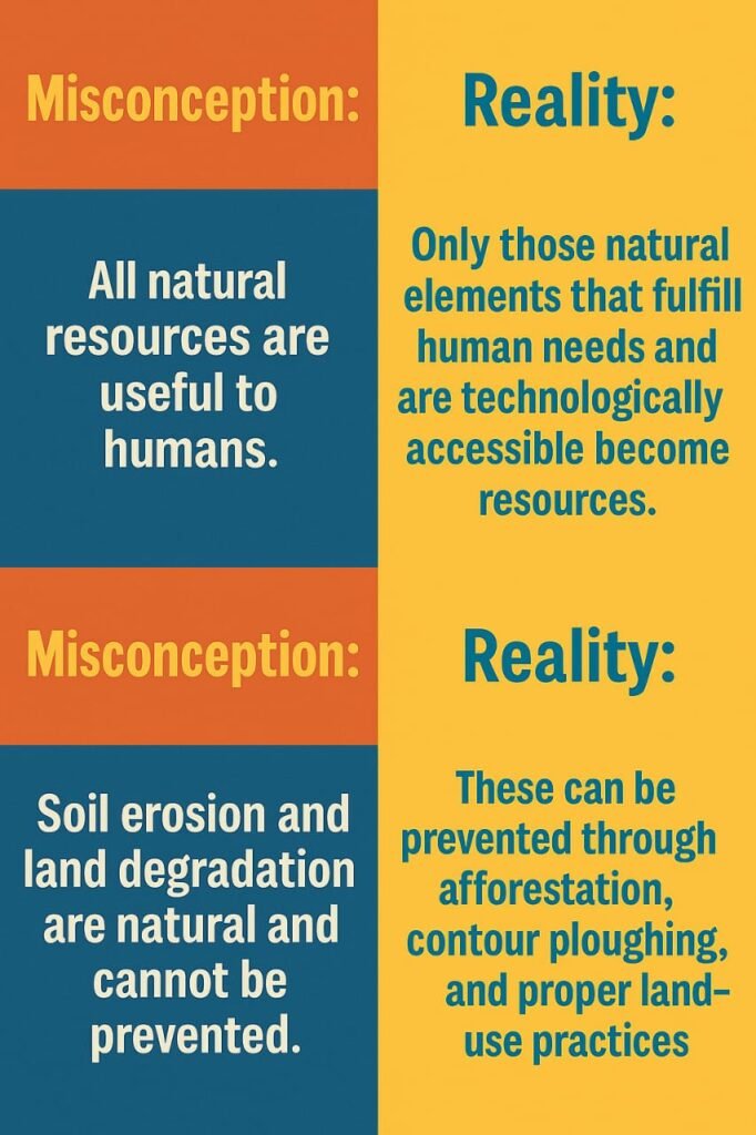
Resources are materials available in our environment that can satisfy human needs, provided they are technologically accessible, economically feasible, and culturally acceptable. The transformation of environmental materials into resources involves an interactive relationship between nature, technology, and institutions. Human beings play a crucial role as they transform natural materials into valuable resources through innovation and technological advancement.
Classification of Resources
Resources can be systematically classified based on four main criteria:
Based on Origin:
Biotic Resources: Derived from living organisms or organic matter, including forests, wildlife, and agricultural products
Abiotic Resources: Composed of non-living materials such as minerals, rocks, water, and soil
Based on Exhaustibility:
Renewable Resources: Can be replenished naturally over time, like solar energy, wind, and water
Non-renewable Resources: Take millions of years to form and are finite in nature, including fossil fuels and minerals
Based on Ownership:
Individual, community, national, and international resources
Based on Development Status:
Potential, developed, stock, and reserve resources
Development of Resources and Sustainable Development
Indiscriminate use of resources has led to several critical problems including resource depletion, unequal distribution creating socio-economic disparities, and global ecological crises such as climate change and environmental pollution. This necessitates sustainable development, which means meeting present needs without compromising future generations’ ability to meet their needs.
The Rio de Janeiro Earth Summit of 1992 was a landmark event where world leaders signed declarations on climate change and biological diversity, endorsing Agenda 21 for achieving sustainable development in the 21st century. Mahatma Gandhi’s philosophy of resource conservation is particularly relevant, emphasizing that “there is enough for everybody’s need and not for anybody’s greed”.
Resource Planning in India
Resource planning is essential for India due to its enormous diversity in resource availability. Some regions are resource-rich but economically backward, while others have poor resource bases but are economically developed. For example, Jharkhand, Chhattisgarh, and Madhya Pradesh are rich in minerals but lack infrastructure, while Rajasthan has abundant solar and wind energy but faces water scarcity.
Resource planning involves three complex steps: identification and inventory of resources through surveying and mapping, evolving appropriate planning structures with technology and institutional setup, and matching resource development plans with national development objectives. India has pursued these goals systematically since the First Five Year Plan.
Land Resources and Utilization
Land is a finite natural resource supporting vegetation, wildlife, human life, and economic activities. India’s total geographical area is 3.28 million square kilometers, with 43% plains suitable for agriculture and industry, 30% mountains ensuring water flow and tourism, and 27% plateau regions rich in minerals and forests.
Land utilization in India includes forests (23.3%), net sown area (45.5%), barren land, non-agricultural uses, fallow lands, and permanent pastures. The forest area remains significantly below the desired 33% outlined in the National Forest Policy.
Soil as a Resource
Soil is a vital renewable resource that takes millions of years to form. India has diverse soil types based on relief, climate, and vegetation. The major soil classifications include:
Alluvial Soils: Most widespread and fertile, covering northern plains and river deltas, rich in potash and phosphoric acid, ideal for cereal crops.
Black Soils: Known as regur soils, ideal for cotton cultivation, found in Deccan plateau regions, excellent moisture retention capacity.
Red and Yellow Soils: Develop on crystalline rocks in low rainfall areas, found in eastern and southern Deccan plateau.
Laterite Soils: Form under tropical climate with intense leaching, suitable for tea and coffee in hilly areas.
Arid Soils: Sandy and saline, found in dry regions, become cultivable with proper irrigation.
Land Degradation and Conservation
Land degradation affects 95% of our basic needs for food, shelter, and clothing. Major causes include deforestation, overgrazing, mining, over-irrigation, and industrial pollution. Different regions face specific challenges: mining-induced degradation in Jharkhand and Odisha, overgrazing in Gujarat and Rajasthan, and waterlogging in Punjab and Haryana.
Conservation measures include afforestation, proper grazing management, contour ploughing, terrace cultivation, strip cropping, and shelter belt plantation. These methods help prevent soil erosion, stabilize sand dunes, and maintain ecological balance for sustainable resource management.
————————————————————————————————————————————————————————————————————————————
QUESTIONS FROM TEXTBOOK
Exercise 1: Multiple Choice Questions
Question 1(i): Which one of the following is the main cause of land degradation in Punjab?
(a) Intensive cultivation
(b) Deforestation
(c) Over irrigation
(d) Overgrazing
Answer: (c) Over irrigation
Over irrigation in Punjab has led to waterlogging problems, which increases soil salinity and alkalinity levels. This excessive water usage disrupts the natural soil chemistry and makes the land less productive for agricultural purposes. The state’s intensive farming practices combined with poor drainage systems have created conditions where excess water cannot be properly managed, leading to permanent damage to soil structure and fertility.
Question 1(ii): In which one of the following states is terrace cultivation practised?
(a) Punjab
(b) Plains of Uttar Pradesh
(c) Haryana
(d) Uttarakhand
Answer: (d) Uttarakhand
Terrace cultivation is primarily practiced in Uttarakhand due to its hilly and mountainous terrain. This agricultural technique involves creating step-like flat areas on slopes to prevent soil erosion and facilitate farming on steep hillsides. The western and central Himalayan regions, including Uttarakhand, have well-developed terrace farming systems that help conserve soil and water while making cultivation possible on otherwise unusable sloped land.
Question 1(iii): In which of the following states black soil is predominantly found?
(a) Uttar Pradesh
(b) Maharashtra
(c) Rajasthan
(d) Jharkhand
Answer: (b) Maharashtra
Black soil, also known as regur soil or black cotton soil, is predominantly found in Maharashtra. This soil type is formed from the weathering of basaltic lava flows in the Deccan trap region. Maharashtra’s plateau areas contain extensive deposits of this fertile soil, which is particularly suitable for cotton cultivation due to its high moisture retention capacity and rich mineral content including calcium carbonate, magnesium, and potash.
Exercise 2: Short Answer Questions (30 words each)
Question 2(i): Name three states having black soil and the crop which is mainly grown in it.
Answer: The three states having black soil are Maharashtra, Madhya Pradesh, and Chhattisgarh. Cotton is the main crop grown in black soil due to its excellent moisture retention properties and high fertility. Black soil’s clayey nature and rich mineral content make it ideal for cotton cultivation, which requires consistent moisture levels throughout its growing period.
Question 2(ii): What type of soil is found in the river deltas of the eastern coast? Give three main features of this type of soil.
Answer: Alluvial soil is found in the river deltas of the eastern coast. Three main features are: First, it is extremely fertile and suitable for intensive agriculture. Second, it contains adequate proportions of potash, phosphoric acid, and lime essential for crop growth. Third, it has excellent water retention capacity and consists of fine particles that support diverse cereal and pulse crops effectively.
Question 2(iii): What steps can be taken to control soil erosion in the hilly areas?
Answer: Soil erosion in hilly areas can be controlled through terrace cultivation, which creates flat surfaces on slopes to prevent water runoff. Contour ploughing along slope lines reduces water flow velocity. Strip cropping involves growing grass strips between crops to break wind force. Afforestation and planting shelter belts help stabilize soil and reduce erosion caused by wind and water action.
Exercise 3: Long Answer Questions (120 words each)
Question 3(i): Explain land use pattern in India and why has the land under forest not increased much since 1960-61?
Answer: India’s land use pattern is determined by both physical factors like topography, climate, and soil types, and human factors including population density, technological capability, and cultural traditions. The country’s total geographical area of 3.28 million square kilometers is utilized for various purposes including forests, agricultural land, settlements, and industrial activities.
The net sown area varies significantly across states, being over 80 percent in Punjab and Haryana but less than 10 percent in northeastern states like Arunachal Pradesh and Mizoram. Currently, India’s forest cover remains far below the desired 33 percent outlined in the National Forest Policy of 1952, which is considered essential for maintaining ecological balance.
Forest land has not increased substantially since 1960-61 due to several factors. Growing population pressure has led to conversion of forest land for agricultural expansion, settlements, and infrastructure development. Industrial growth has required land for factories, mining activities, and transportation networks. Additionally, the livelihood needs of millions of people living on forest fringes have resulted in encroachment and degradation of forest areas, making forest conservation and expansion challenging despite policy initiatives.
Question 3(ii): How have technical and economic development led to more consumption of resources?
Answer: Technical and economic development have significantly increased resource consumption through various interconnected mechanisms. Large-scale industrialization has created mass production systems that require enormous quantities of raw materials, energy, and natural resources to meet growing market demands and consumer expectations.
Technological advancement has enabled greater exploitation of previously inaccessible resources through improved extraction techniques, machinery, and processing methods. This has made resource utilization more efficient but also more intensive, leading to faster depletion of available reserves. Advanced technology has also created new products and services that require additional resource inputs.
Economic growth has improved living standards and increased purchasing power, leading to higher consumer demand for goods and services. Urban lifestyle changes have promoted consumption patterns that require more processed foods, manufactured goods, and energy-intensive services. The expansion of transportation networks, communication systems, and industrial infrastructure has created additional resource demands.
Furthermore, improved medical and health facilities have led to population growth, which directly correlates with increased resource consumption. The shift from traditional sustainable practices to modern consumption-oriented lifestyles has disrupted the natural balance between resource availability and human needs, creating unprecedented pressure on natural resources globally.
————————————————————————————————————————————————————————————————————————————
OTHER IMPORTANT QUESTIONS FOR EXAMS
[ CBSE MODEL QUESTION PAPER]
🔷 Section A: Multiple Choice Questions (1 × 6 = 6 marks)
Q1. Which of the following resources can be renewed or reproduced by physical, chemical, or mechanical processes?
(a) Non-renewable resources
(b) Renewable resources
(c) Biotic resources
(d) Stock resources
Answer: (b) Renewable resources
Q2. On the basis of origin, resources are classified as:
(a) Renewable and Non-renewable
(b) Individual and Community
(c) Biotic and Abiotic
(d) National and International
Answer: (c) Biotic and Abiotic
Q3. The black soil found in the Deccan plateau is ideal for growing:
(a) Tea
(b) Wheat
(c) Cotton
(d) Rice
Answer: (c) Cotton
Q4. Which of the following methods is most effective for soil conservation in arid regions?
(a) Contour ploughing
(b) Strip cropping
(c) Shelter belts
(d) Terrace farming
Answer: (c) Shelter belts
Q5. Which of the following statements best defines sustainable development?
(a) Maximizing resource use to meet present needs
(b) Utilizing resources endlessly for development
(c) Meeting present needs without compromising future generations
(d) Developing all available resources rapidly
Answer: (c) Meeting present needs without compromising future generations
Q6. Which type of resource is iron ore?
(a) Biotic and renewable
(b) Abiotic and renewable
(c) Biotic and non-renewable
(d) Abiotic and non-renewable
Answer: (d) Abiotic and non-renewable
🔷 Section B: Very Short Answer Questions (2 × 6 = 12 marks)
Answer in 30–40 words.
Q7. What is meant by resource planning?
Answer:
Resource planning is the strategy for judicious use of resources. It involves identifying resources, planning their development, and using them efficiently to avoid overexploitation and ensure sustainability.
Q8. Why is land considered an important resource?
Answer:
Land provides the base for all human activities such as agriculture, forestry, industries, and housing. It supports natural vegetation and wildlife and determines population distribution.
Q9. Define soil erosion. Mention any one human activity responsible for it.
Answer:
Soil erosion is the removal of topsoil by natural forces like wind or water. One major human activity causing soil erosion is deforestation or indiscriminate cutting of trees.
Q10. Name any two soil types found in India and mention one crop suitable for each.
Answer:
Alluvial Soil – suitable for wheat.
Black Soil – ideal for cotton cultivation.
Q11. How is over-irrigation responsible for land degradation?
Answer:
Over-irrigation causes waterlogging, which leads to increased salinity and alkalinity of the soil, rendering it infertile and unfit for cultivation.
Q12. Mention any two factors that determine the land-use pattern in India.
Answer:
Physical factors such as topography and soil type.
Human factors like population density and technological development.
🔷 Section C: Short Answer Questions (3 × 12 = 36 marks)
Answer in 80–100 words.
Q13. Why is resource planning essential in India? Explain any three reasons.
Answer:
Resources are unevenly distributed, causing regional imbalances.
Some areas face resource scarcity while others have overuse or underuse.
To ensure sustainable development and avoid environmental degradation, planning is necessary for efficient utilization.
Q14. What steps are involved in the resource planning process?
Answer:
Identification and inventory of resources through surveys and mapping.
Evolving a planning structure using appropriate technology and institutional set-up.
Matching resource development with overall national development plans.
Q15. Distinguish between renewable and non-renewable resources with examples.
Answer:
Renewable Resources: Can be replenished naturally (e.g., solar energy, water).
Non-renewable Resources: Formed over long geological periods, cannot be renewed (e.g., coal, petroleum).
Q16. What are the major causes of land degradation in India?
Answer:
Deforestation for agriculture and urban expansion.
Over-irrigation causing waterlogging and salinity.
Overgrazing and mining activities that remove vegetation and topsoil.
Q17. Describe any three features of alluvial soil.
Answer:
Found in river valleys and deltas, mainly in the Northern Plains.
Rich in potash and suitable for growing wheat, rice, sugarcane.
Renewed every year by floods; highly fertile and deep.
Q18. Explain any three features of black soil.
Answer:
Rich in clay, moisture-retentive, ideal for cotton.
Develops cracks in summer, aiding aeration.
Found mainly in Maharashtra, Madhya Pradesh, and Gujarat.
Q19. Explain how contour ploughing and terrace farming help in soil conservation.
Answer:
Contour ploughing involves ploughing along contour lines to reduce runoff and erosion.
Terrace farming creates flat steps on slopes, reducing water flow and conserving soil in hilly areas.
Q20. What are the causes and consequences of soil erosion in India?
Answer:
Causes: Deforestation, overgrazing, and improper farming practices.
Consequences: Loss of fertile topsoil, reduced agricultural productivity, and ecological imbalance.
Q21. Differentiate between actual and potential resources.
Answer:
Actual Resources: Resources whose quantity and location are known and are being used (e.g., coal in Jharia).
Potential Resources: Resources available in a region but not yet utilized (e.g., solar energy in Rajasthan).
Q22. What is meant by sustainable development? Why is it necessary?
Answer:
Sustainable development means using resources in a way that meets present needs without harming future generations. It is necessary to ensure resource availability, environmental protection, and long-term economic growth.
Q23. Mention three human factors that influence the land-use pattern in India.
Answer:
Population density and urbanization.
Technological development and irrigation facilities.
Cultural and economic practices of the people.
Q24. How can land be conserved from degradation? Give any three measures.
Answer:
Afforestation and proper management of grazing.
Controlled mining and regulated use of chemical fertilizers.
Promoting terrace farming and crop rotation.
🔷 Section D: Long Answer Questions (5 × 5 = 25 marks)
Answer in 120–150 words.
Q25. Explain the classification of resources on the basis of ownership with suitable examples.
Answer:
Individual Resources: Owned by individuals (e.g., farmland, houses).
Community-Owned Resources: Used by all community members (e.g., grazing grounds, village ponds).
National Resources: Belong to the nation, used by the government (e.g., roads, railways).
International Resources: Regulated by international institutions, beyond national boundaries (e.g., oceanic resources beyond EEZ).
Ownership classification helps in legal and developmental planning.
Q26. Define soil erosion and explain different types of soil erosion.
Answer:
Soil erosion is the removal of topsoil due to natural forces like water and wind.
Sheet Erosion: Uniform removal of soil.
Rill Erosion: Formation of shallow channels.
Gully Erosion: Deep ditches formed, common in Chambal Valley.
Wind Erosion: Blowing away of soil in arid regions.
All these forms reduce soil fertility and lead to land degradation.
Q27. What are the main characteristics and significance of red and laterite soils?
Answer:
Red Soil: Found in Tamil Nadu, Odisha, Chhattisgarh; formed from crystalline rocks; less fertile but good for millets.
Laterite Soil: Found in high rainfall areas; low fertility due to leaching; suitable for tea, coffee after manuring.
Both need proper care and fertilization to be agriculturally productive.
Q28. Explain the need for resource conservation. Mention any four steps for it.
Answer:
Overuse and wasteful exploitation have led to resource depletion. Conservation ensures sustainability and intergenerational equity.
Steps:
Judicious use of resources.
Recycling and reuse.
Awareness and education.
Enforcing legal and policy measures for protection.
Q29. Suggest measures to solve the problem of land degradation in India.
Answer:
Afforestation and reforestation.
Controlled grazing and regulated mining.
Use of organic fertilizers and bio-pesticides.
Practicing crop rotation and terrace farming.
Promoting sustainable irrigation and land use techniques.
Q30. On the given political map of India, locate and label the following:
(a) A region with black soil
(b) A region where laterite soil is found
Answer:
(a) Maharashtra (e.g., Nagpur – Black Soil region)
(b) Kerala (e.g., Wayanad – Laterite Soil region)
Q31. On the outline map of India, mark the following types of land degradation:
(a) A region affected by over-irrigation
(b) A region affected by deforestation
Answer:
(a) Punjab/Haryana (Over-irrigation leading to salinity)
(b) Jharkhand/Chhattisgarh (Deforestation-induced degradation)
🔷 Section F: Case-Based Questions (6 × 4 = 24 marks)
Each case carries 4 questions (1 mark each).
Q32. Read the passage and answer the following questions:
“India’s land resource is varied in nature. About 43% is used for agriculture, 22% is forest land, and the rest is under non-agricultural use, barren land, or grazing grounds. The quality of land also varies from place to place.”
(i) What percentage of Indian land is used for agriculture?
Answer: 43%
(ii) What is the percentage of forest land in India?
Answer: 22%
(iii) Name any two non-agricultural uses of land.
Answer: Housing, industries
(iv) What does the passage tell us about land quality in India?
Answer: It varies from region to region.
Q33. Read the passage and answer the following questions:
“Black soil is ideal for growing cotton and is also known as ‘regur’ soil. It is made up of extremely fine particles and is moisture-retentive. It develops deep cracks during hot weather, which helps in aeration.”
(i) Which crop is best suited for black soil?
Answer: Cotton
(ii) What is another name for black soil?
Answer: Regur soil
(iii) Why are deep cracks beneficial in black soil?
Answer: They help in soil aeration.
(iv) Mention one key physical property of black soil.
Answer: High moisture retention capacity
Q34. Read the passage and answer the following questions:
“Land degradation in India is a serious concern. Overgrazing, deforestation, and excessive use of chemical fertilizers are some major causes. The degraded land loses its fertility, affecting productivity and the environment.”
(i) Mention any one human activity causing land degradation.
Answer: Overgrazing
(ii) What is the impact of land degradation on agriculture?
Answer: Loss of soil fertility reduces productivity.
(iii) How do chemical fertilizers degrade land?
Answer: They alter soil structure and reduce microbial activity.
(iv) Why is land degradation a serious concern?
Answer: It threatens food security and ecological balance.
Q35. Read the passage and answer the following questions:
“Laterite soil is found in high rainfall and high-temperature regions. It is formed due to intense leaching and is low in fertility. However, with proper treatment, it can be used to grow crops like tea and coffee.”
(i) What causes the formation of laterite soil?
Answer: Intense leaching in wet and hot climates
(ii) Name one crop suitable for laterite soil after treatment.
Answer: Tea
(iii) Why is laterite soil not naturally fertile?
Answer: Due to leaching of nutrients
(iv) In which type of region is laterite soil found?
Answer: High rainfall and high-temperature regions
Q36. Read the passage and answer the following questions:
“Sustainable development implies using resources in a way that allows them to renew and serve future generations. It involves reducing wastage, conserving biodiversity, and balancing economic growth with environmental protection.”
(i) What is the key goal of sustainable development?
Answer: To meet present needs without compromising future generations
(ii) How does sustainable development help biodiversity?
Answer: By conserving ecosystems and species
(iii) Give one method to reduce resource wastage.
Answer: Recycling and reuse
(iv) What must be balanced in sustainable development?
Answer: Economic growth and environmental protection
Q37. Read the passage and answer the following questions:
“Resource planning is vital for India due to the unequal distribution of resources. Some states like Rajasthan have abundant solar and wind energy, while others like Jharkhand have rich mineral deposits. Planning ensures equitable development.”
(i) Why is resource planning important in India?
Answer: Due to uneven distribution of resources
(ii) Name one resource abundant in Rajasthan.
Answer: Solar energy
(iii) Which state is rich in mineral resources?
Answer: Jharkhand
(iv) What does planning ensure?
Answer: Equitable and efficient development
————————————————————————————————————————————————————————————————————————————
QUESTIONS FROM COMPETITION EXAMS
————————————————————————————————————————————————————————————————————————————
ONE PAGE REVISION SHEET
Definition of Resources:
Resources are all useful elements of the environment that satisfy human needs and are technologically, economically, and culturally viable to use.
Types of Resources (by Origin):
Biotic: Living (e.g. plants, animals)
Abiotic: Non-living (e.g. minerals, water)
Types of Resources (by Exhaustibility):
Renewable: Replenishable (e.g. sunlight, forests)
Non-Renewable: Limited (e.g. coal, oil)
Types of Resources (by Ownership):
Individual, Community, National, and International resources
Types of Resources (by Development Status):
Potential, Developed, Stock, and Reserves
Need for Resource Planning:
Unequal distribution of resources requires balanced planning for sustainable and equitable development.
Land Use in India:
Includes agriculture, forests, grazing, and non-agricultural uses. Land is both renewable and prone to degradation.
Land Degradation and Conservation:
Caused by deforestation, over-irrigation, and mining. Controlled by afforestation, regulated grazing, and proper irrigation.
Types of Soils in India:
Alluvial, Black, Red & Yellow, Laterite, Arid, and Forest Soils, each with specific crops and regions.
Soil Erosion and Conservation:
Erosion by water/wind can be checked by contour ploughing, shelter belts, and terrace farming.
————————————————————————————————————————————————————————————————————————————
MISCONCEPTIONS “ALERTS”
————————————————————————————————————————————————————————————————————————————